You are here: Home > Network List > TA - USArray Transportable Network (new EarthScope stations) Stations List
> Station F26K Sheenjek River, AK, USA > Earthquake Result Viewer
F26K Sheenjek River, AK, USA - Earthquake Result Viewer

| Earthquake location: |
New Guinea, Papua New Guinea |
| Earthquake latitude/longitude: |
-5.8/142.5 |
| Earthquake time(UTC): |
2018/04/07 (097) 05:48:38 GMT |
| Earthquake Depth: |
10 km |
| Earthquake Magnitude: |
6.3 Mww |
| Earthquake Catalog/Contributor: |
NEIC PDE/us |
|
| Network: |
TA USArray Transportable Network (new EarthScope stations) |
| Station: |
F26K Sheenjek River, AK, USA |
| Lat/Lon: |
67.69 N/144.15 W |
| Elevation: |
683 m |
|
| Distance: |
89.1 deg |
| Az: |
21.457 deg |
| Baz: |
252.43 deg |
| Ray Param: |
0.042078584 |
| Estimated Moho Depth: |
17.5 km |
| Estimated Crust Vp/Vs: |
1.84 |
| Assumed Crust Vp: |
6.522 km/s |
| Estimated Crust Vs: |
3.554 km/s |
| Estimated Crust Poisson's Ratio: |
0.29 |
|
| Radial Match: |
87.379906 % |
| Radial Bump: |
400 |
| Transverse Match: |
73.96119 % |
| Transverse Bump: |
400 |
| SOD ConfigId: |
13570011 |
| Insert Time: |
2019-04-30 02:29:21.431 +0000 |
| GWidth: |
2.5 |
| Max Bumps: |
400 |
| Tol: |
0.001 |
|
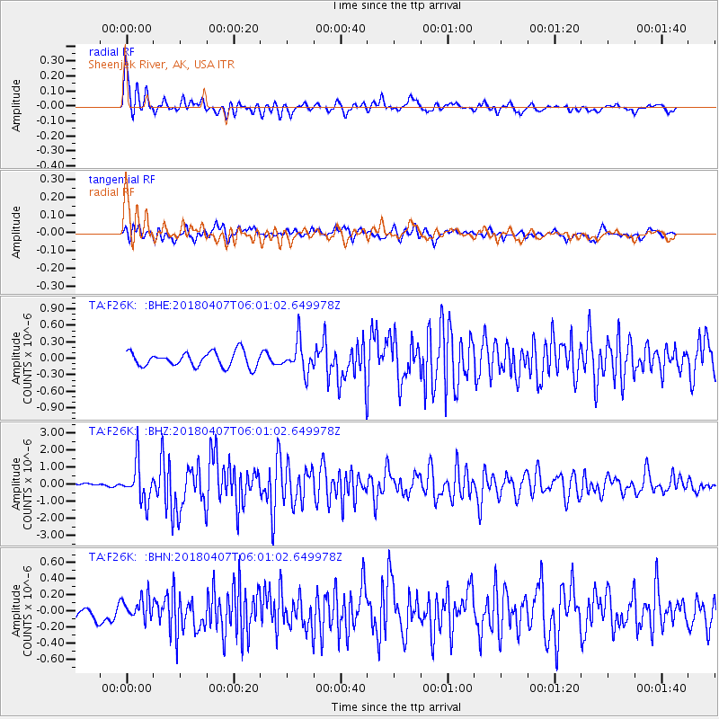
Signal To Noise
| Channel | StoN | STA | LTA |
| TA:F26K: :BHZ:20180407T06:01:02.649978Z | 8.785774 | 1.1466603E-6 | 1.3051329E-7 |
| TA:F26K: :BHN:20180407T06:01:02.649978Z | 1.0001221 | 1.3866483E-7 | 1.386479E-7 |
| TA:F26K: :BHE:20180407T06:01:02.649978Z | 2.122854 | 2.8356908E-7 | 1.3357918E-7 |
| Arrivals |
| Ps | 2.3 SECOND |
| PpPs | 7.4 SECOND |
| PsPs/PpSs | 9.7 SECOND |


