You are here: Home > Network List > TA - USArray Transportable Network (new EarthScope stations) Stations List
> Station O19A Miners Draw (BLM), Jensen, UT, USA > Earthquake Result Viewer
O19A Miners Draw (BLM), Jensen, UT, USA - Earthquake Result Viewer
| Earthquake location: |
Andreanof Islands, Aleutian Is. |
| Earthquake latitude/longitude: |
52.2/-175.7 |
| Earthquake time(UTC): |
2008/08/07 (220) 18:30:03 GMT |
| Earthquake Depth: |
12 km |
| Earthquake Magnitude: |
5.6 MB, 5.5 MS, 5.8 MW, 5.8 MW |
| Earthquake Catalog/Contributor: |
WHDF/NEIC |
|
| Network: |
TA USArray Transportable Network (new EarthScope stations) |
| Station: |
O19A Miners Draw (BLM), Jensen, UT, USA |
| Lat/Lon: |
40.30 N/109.12 W |
| Elevation: |
1649 m |
|
| Distance: |
46.0 deg |
| Az: |
77.422 deg |
| Baz: |
308.225 deg |
| Ray Param: |
0.07093878 |
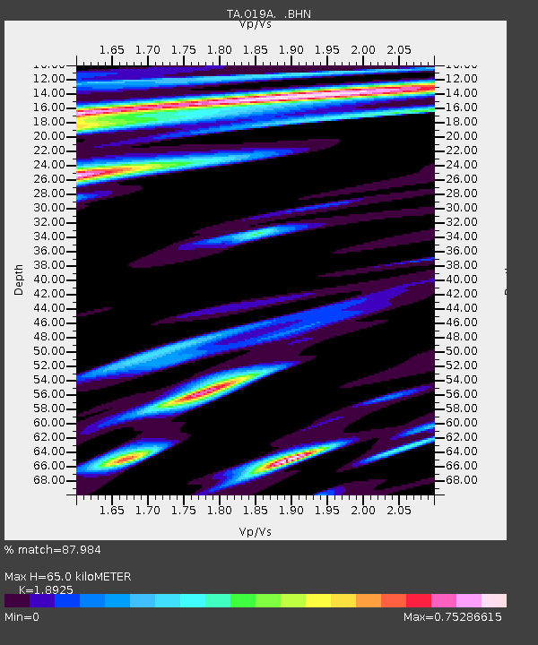
| Estimated Moho Depth: |
65.0 km |
| Estimated Crust Vp/Vs: |
1.89 |
| Assumed Crust Vp: |
6.207 km/s |
| Estimated Crust Vs: |
3.28 km/s |
| Estimated Crust Poisson's Ratio: |
0.31 |
|
| Radial Match: |
87.984 % |
| Radial Bump: |
400 |
| Transverse Match: |
55.79585 % |
| Transverse Bump: |
400 |
| SOD ConfigId: |
2504 |
| Insert Time: |
2010-03-06 10:29:59.487 +0000 |
| GWidth: |
2.5 |
| Max Bumps: |
400 |
| Tol: |
0.001 |
|

Signal To Noise
| Channel | StoN | STA | LTA |
| TA:O19A: :BHN:20080807T18:37:54.873986Z | 9.011397 | 5.030822E-7 | 5.5827325E-8 |
| TA:O19A: :BHE:20080807T18:37:54.873986Z | 1.0708331 | 2.095242E-7 | 1.9566465E-7 |
| TA:O19A: :BHZ:20080807T18:37:54.873986Z | 0.84274787 | 1.4483301E-7 | 1.7185806E-7 |
| Arrivals |
| Ps | 9.9 SECOND |
| PpPs | 29 SECOND |
| PsPs/PpSs | 39 SECOND |


