You are here: Home > Network List > TA - USArray Transportable Network (new EarthScope stations) Stations List
> Station M20K Styx River, AK, USA > Earthquake Result Viewer
M20K Styx River, AK, USA - Earthquake Result Viewer
| Earthquake location: |
New Guinea, Papua New Guinea |
| Earthquake latitude/longitude: |
-5.8/142.5 |
| Earthquake time(UTC): |
2018/04/07 (097) 05:48:38 GMT |
| Earthquake Depth: |
10 km |
| Earthquake Magnitude: |
6.3 Mww |
| Earthquake Catalog/Contributor: |
NEIC PDE/us |
|
| Network: |
TA USArray Transportable Network (new EarthScope stations) |
| Station: |
M20K Styx River, AK, USA |
| Lat/Lon: |
61.88 N/153.13 W |
| Elevation: |
1107 m |
|
| Distance: |
83.4 deg |
| Az: |
25.468 deg |
| Baz: |
244.558 deg |
| Ray Param: |
0.04620897 |
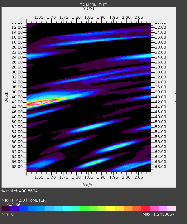
| Estimated Moho Depth: |
42.0 km |
| Estimated Crust Vp/Vs: |
1.66 |
| Assumed Crust Vp: |
6.566 km/s |
| Estimated Crust Vs: |
3.956 km/s |
| Estimated Crust Poisson's Ratio: |
0.22 |
|
| Radial Match: |
80.5634 % |
| Radial Bump: |
400 |
| Transverse Match: |
78.29067 % |
| Transverse Bump: |
400 |
| SOD ConfigId: |
13570011 |
| Insert Time: |
2019-04-30 02:30:19.407 +0000 |
| GWidth: |
2.5 |
| Max Bumps: |
400 |
| Tol: |
0.001 |
|

Signal To Noise
| Channel | StoN | STA | LTA |
| TA:M20K: :BHZ:20180407T06:00:34.625015Z | 5.521089 | 1.57471E-6 | 2.8521728E-7 |
| TA:M20K: :BHN:20180407T06:00:34.625015Z | 2.6714475 | 5.4180487E-7 | 2.0281321E-7 |
| TA:M20K: :BHE:20180407T06:00:34.625015Z | 1.8741076 | 4.4209096E-7 | 2.3589412E-7 |
| Arrivals |
| Ps | 4.3 SECOND |
| PpPs | 17 SECOND |
| PsPs/PpSs | 21 SECOND |


