You are here: Home > Network List > TA - USArray Transportable Network (new EarthScope stations) Stations List
> Station O19A Miners Draw (BLM), Jensen, UT, USA > Earthquake Result Viewer
O19A Miners Draw (BLM), Jensen, UT, USA - Earthquake Result Viewer

| Earthquake location: |
Kuril Islands |
| Earthquake latitude/longitude: |
46.0/151.4 |
| Earthquake time(UTC): |
2009/04/18 (108) 19:17:58 GMT |
| Earthquake Depth: |
35 km |
| Earthquake Magnitude: |
6.3 MB, 6.3 MS, 6.6 MW, 6.4 MW |
| Earthquake Catalog/Contributor: |
WHDF/NEIC |
|
| Network: |
TA USArray Transportable Network (new EarthScope stations) |
| Station: |
O19A Miners Draw (BLM), Jensen, UT, USA |
| Lat/Lon: |
40.30 N/109.12 W |
| Elevation: |
1649 m |
|
| Distance: |
68.0 deg |
| Az: |
54.456 deg |
| Baz: |
312.15 deg |
| Ray Param: |
0.056531616 |
| Estimated Moho Depth: |
18.25 km |
| Estimated Crust Vp/Vs: |
1.60 |
| Assumed Crust Vp: |
6.207 km/s |
| Estimated Crust Vs: |
3.879 km/s |
| Estimated Crust Poisson's Ratio: |
0.18 |
|
| Radial Match: |
86.76024 % |
| Radial Bump: |
400 |
| Transverse Match: |
65.568855 % |
| Transverse Bump: |
400 |
| SOD ConfigId: |
2658 |
| Insert Time: |
2010-03-06 10:31:11.139 +0000 |
| GWidth: |
2.5 |
| Max Bumps: |
400 |
| Tol: |
0.001 |
|
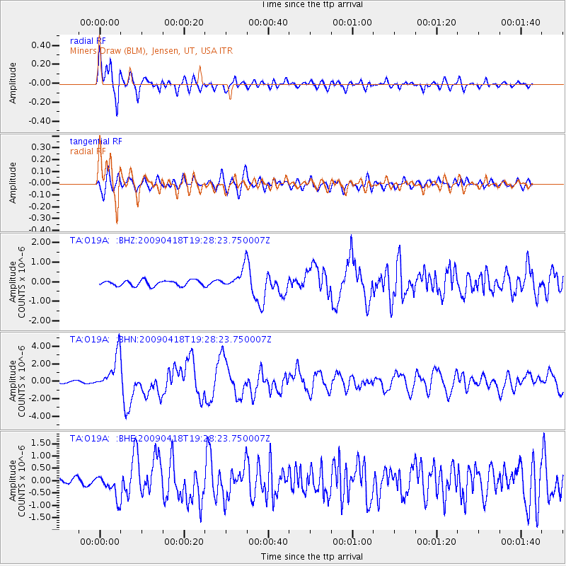
Signal To Noise
| Channel | StoN | STA | LTA |
| TA:O19A: :BHN:20090418T19:28:23.750007Z | 19.922913 | 2.1018761E-6 | 1.0550044E-7 |
| TA:O19A: :BHE:20090418T19:28:23.750007Z | 3.960164 | 4.8153476E-7 | 1.2159465E-7 |
| TA:O19A: :BHZ:20090418T19:28:23.750007Z | 3.9654784 | 5.515917E-7 | 1.3909839E-7 |
| Arrivals |
| Ps | 1.8 SECOND |
| PpPs | 7.3 SECOND |
| PsPs/PpSs | 9.2 SECOND |


