You are here: Home > Network List > TA - USArray Transportable Network (new EarthScope stations) Stations List
> Station O19A Miners Draw (BLM), Jensen, UT, USA > Earthquake Result Viewer
O19A Miners Draw (BLM), Jensen, UT, USA - Earthquake Result Viewer
| Earthquake location: |
Off Coast Of Ecuador |
| Earthquake latitude/longitude: |
1.4/-85.2 |
| Earthquake time(UTC): |
2009/05/10 (130) 01:16:06 GMT |
| Earthquake Depth: |
6.0 km |
| Earthquake Magnitude: |
5.5 MB, 5.7 MS, 6.1 MW, 6.1 MW |
| Earthquake Catalog/Contributor: |
WHDF/NEIC |
|
| Network: |
TA USArray Transportable Network (new EarthScope stations) |
| Station: |
O19A Miners Draw (BLM), Jensen, UT, USA |
| Lat/Lon: |
40.30 N/109.12 W |
| Elevation: |
1649 m |
|
| Distance: |
44.4 deg |
| Az: |
333.659 deg |
| Baz: |
144.551 deg |
| Ray Param: |
0.07194156 |
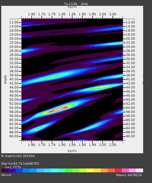
| Estimated Moho Depth: |
54.75 km |
| Estimated Crust Vp/Vs: |
1.78 |
| Assumed Crust Vp: |
6.207 km/s |
| Estimated Crust Vs: |
3.492 km/s |
| Estimated Crust Poisson's Ratio: |
0.27 |
|
| Radial Match: |
83.382454 % |
| Radial Bump: |
400 |
| Transverse Match: |
57.789177 % |
| Transverse Bump: |
400 |
| SOD ConfigId: |
2760 |
| Insert Time: |
2010-03-06 10:31:25.176 +0000 |
| GWidth: |
2.5 |
| Max Bumps: |
400 |
| Tol: |
0.001 |
|
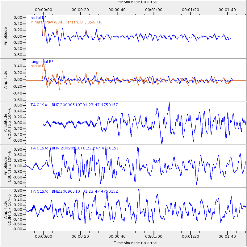
Signal To Noise
| Channel | StoN | STA | LTA |
| TA:O19A: :BHN:20090510T01:23:47.475015Z | 5.107528 | 4.1392366E-7 | 8.1041875E-8 |
| TA:O19A: :BHE:20090510T01:23:47.475015Z | 1.3403982 | 1.7201141E-7 | 1.283286E-7 |
| TA:O19A: :BHZ:20090510T01:23:47.475015Z | 3.1634839 | 1.7645526E-7 | 5.577878E-8 |
| Arrivals |
| Ps | 7.3 SECOND |
| PpPs | 23 SECOND |
| PsPs/PpSs | 30 SECOND |


