You are here: Home > Network List > TA - USArray Transportable Network (new EarthScope stations) Stations List
> Station O19A Miners Draw (BLM), Jensen, UT, USA > Earthquake Result Viewer
O19A Miners Draw (BLM), Jensen, UT, USA - Earthquake Result Viewer
| Earthquake location: |
Andreanof Islands, Aleutian Is. |
| Earthquake latitude/longitude: |
52.2/-178.7 |
| Earthquake time(UTC): |
2008/03/22 (082) 21:24:11 GMT |
| Earthquake Depth: |
132 km |
| Earthquake Magnitude: |
5.8 MB, 6.2 MW, 6.1 MW |
| Earthquake Catalog/Contributor: |
WHDF/NEIC |
|
| Network: |
TA USArray Transportable Network (new EarthScope stations) |
| Station: |
O19A Miners Draw (BLM), Jensen, UT, USA |
| Lat/Lon: |
40.30 N/109.12 W |
| Elevation: |
1649 m |
|
| Distance: |
47.8 deg |
| Az: |
75.409 deg |
| Baz: |
308.813 deg |
| Ray Param: |
0.06931665 |
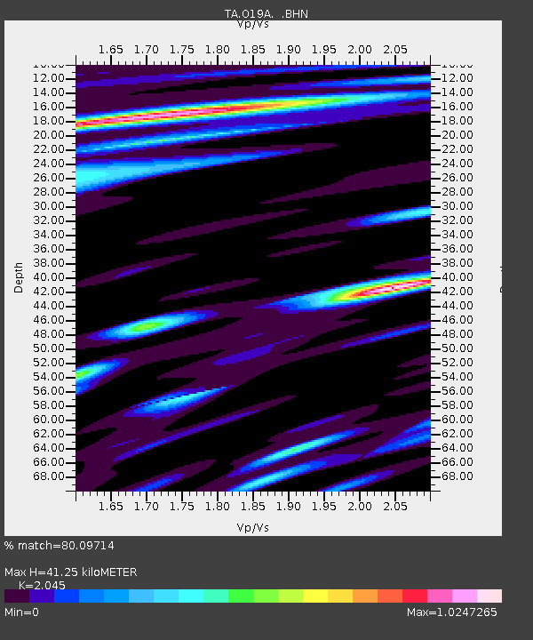
| Estimated Moho Depth: |
41.25 km |
| Estimated Crust Vp/Vs: |
2.05 |
| Assumed Crust Vp: |
6.207 km/s |
| Estimated Crust Vs: |
3.035 km/s |
| Estimated Crust Poisson's Ratio: |
0.34 |
|
| Radial Match: |
80.09714 % |
| Radial Bump: |
400 |
| Transverse Match: |
73.45247 % |
| Transverse Bump: |
400 |
| SOD ConfigId: |
2564 |
| Insert Time: |
2010-03-06 10:31:27.991 +0000 |
| GWidth: |
2.5 |
| Max Bumps: |
400 |
| Tol: |
0.001 |
|

Signal To Noise
| Channel | StoN | STA | LTA |
| TA:O19A: :BHN:20080322T21:32:04.750011Z | 6.927572 | 1.3160058E-6 | 1.8996639E-7 |
| TA:O19A: :BHE:20080322T21:32:04.750011Z | 4.2758965 | 1.0626861E-6 | 2.485294E-7 |
| TA:O19A: :BHZ:20080322T21:32:04.750011Z | 21.168537 | 3.6291692E-6 | 1.7144167E-7 |
| Arrivals |
| Ps | 7.3 SECOND |
| PpPs | 19 SECOND |
| PsPs/PpSs | 27 SECOND |


