You are here: Home > Network List > TA - USArray Transportable Network (new EarthScope stations) Stations List
> Station F21K Alatna River, AK, USA > Earthquake Result Viewer
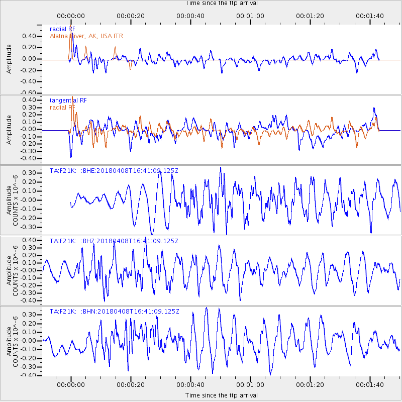
F21K Alatna River, AK, USA - Earthquake Result Viewer
*The percent match for this event was below the threshold and hence no stack was calculated.
| Earthquake location: |
Western Honshu, Japan |
| Earthquake latitude/longitude: |
35.3/132.5 |
| Earthquake time(UTC): |
2018/04/08 (098) 16:32:31 GMT |
| Earthquake Depth: |
9.4 km |
| Earthquake Magnitude: |
5.7 Mww |
| Earthquake Catalog/Contributor: |
NEIC PDE/us |
|
| Network: |
TA USArray Transportable Network (new EarthScope stations) |
| Station: |
F21K Alatna River, AK, USA |
| Lat/Lon: |
67.22 N/153.48 W |
| Elevation: |
597 m |
|
| Distance: |
51.9 deg |
| Az: |
28.405 deg |
| Baz: |
271.144 deg |
| Ray Param: |
$rayparam |
*The percent match for this event was below the threshold and hence was not used in the summary stack. |
|
| Radial Match: |
54.65839 % |
| Radial Bump: |
400 |
| Transverse Match: |
51.47411 % |
| Transverse Bump: |
400 |
| SOD ConfigId: |
13570011 |
| Insert Time: |
2019-04-30 02:37:49.929 +0000 |
| GWidth: |
2.5 |
| Max Bumps: |
400 |
| Tol: |
0.001 |
|
Signal To Noise
| Channel | StoN | STA | LTA |
| TA:F21K: :BHZ:20180408T16:41:09.125Z | 1.2989677 | 1.2431397E-7 | 9.570212E-8 |
| TA:F21K: :BHN:20180408T16:41:09.125Z | 0.6013357 | 9.8614905E-8 | 1.639931E-7 |
| TA:F21K: :BHE:20180408T16:41:09.125Z | 2.5239155 | 2.29611E-7 | 9.097412E-8 |
| Arrivals |
| Ps | |
| PpPs | |
| PsPs/PpSs | |


