You are here: Home > Network List > TA - USArray Transportable Network (new EarthScope stations) Stations List
> Station O19A Miners Draw (BLM), Jensen, UT, USA > Earthquake Result Viewer
O19A Miners Draw (BLM), Jensen, UT, USA - Earthquake Result Viewer
| Earthquake location: |
Loyalty Islands |
| Earthquake latitude/longitude: |
-20.1/168.9 |
| Earthquake time(UTC): |
2008/04/09 (100) 12:46:12 GMT |
| Earthquake Depth: |
33 km |
| Earthquake Magnitude: |
6.3 MB, 7.3 MS, 7.3 MW, 7.3 MW |
| Earthquake Catalog/Contributor: |
WHDF/NEIC |
|
| Network: |
TA USArray Transportable Network (new EarthScope stations) |
| Station: |
O19A Miners Draw (BLM), Jensen, UT, USA |
| Lat/Lon: |
40.30 N/109.12 W |
| Elevation: |
1649 m |
|
| Distance: |
96.9 deg |
| Az: |
49.714 deg |
| Baz: |
249.643 deg |
| Ray Param: |
0.040370766 |
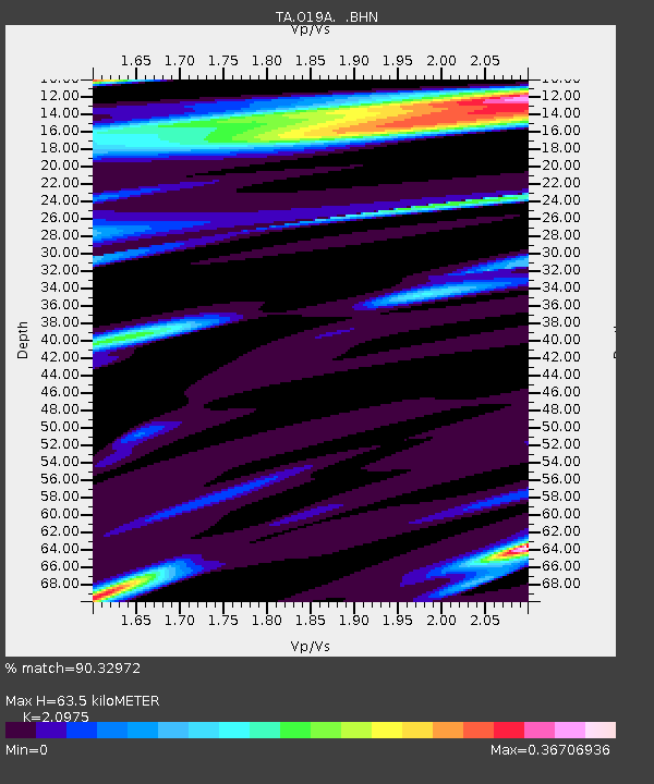
| Estimated Moho Depth: |
63.5 km |
| Estimated Crust Vp/Vs: |
2.10 |
| Assumed Crust Vp: |
6.207 km/s |
| Estimated Crust Vs: |
2.959 km/s |
| Estimated Crust Poisson's Ratio: |
0.35 |
|
| Radial Match: |
90.32972 % |
| Radial Bump: |
284 |
| Transverse Match: |
74.69625 % |
| Transverse Bump: |
343 |
| SOD ConfigId: |
2504 |
| Insert Time: |
2010-03-06 10:31:30.036 +0000 |
| GWidth: |
2.5 |
| Max Bumps: |
400 |
| Tol: |
0.001 |
|

Signal To Noise
| Channel | StoN | STA | LTA |
| TA:O19A: :BHN:20080409T12:59:08.949004Z | 2.797367 | 1.0295944E-6 | 3.6805838E-7 |
| TA:O19A: :BHE:20080409T12:59:08.949004Z | 1.4085188 | 3.3836088E-7 | 2.4022464E-7 |
| TA:O19A: :BHZ:20080409T12:59:08.949004Z | 1.2182002 | 5.9623613E-7 | 4.8944014E-7 |
| Arrivals |
| Ps | 11 SECOND |
| PpPs | 31 SECOND |
| PsPs/PpSs | 43 SECOND |


