You are here: Home > Network List > TA - USArray Transportable Network (new EarthScope stations) Stations List
> Station H31M Peel River, Yukon, CAN > Earthquake Result Viewer
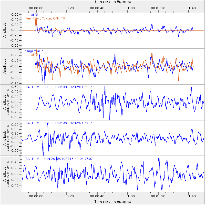
H31M Peel River, Yukon, CAN - Earthquake Result Viewer
*The percent match for this event was below the threshold and hence no stack was calculated.
| Earthquake location: |
Western Honshu, Japan |
| Earthquake latitude/longitude: |
35.3/132.5 |
| Earthquake time(UTC): |
2018/04/08 (098) 16:32:31 GMT |
| Earthquake Depth: |
9.4 km |
| Earthquake Magnitude: |
5.7 Mww |
| Earthquake Catalog/Contributor: |
NEIC PDE/us |
|
| Network: |
TA USArray Transportable Network (new EarthScope stations) |
| Station: |
H31M Peel River, Yukon, CAN |
| Lat/Lon: |
65.81 N/134.34 W |
| Elevation: |
642 m |
|
| Distance: |
59.7 deg |
| Az: |
28.481 deg |
| Baz: |
288.751 deg |
| Ray Param: |
$rayparam |
*The percent match for this event was below the threshold and hence was not used in the summary stack. |
|
| Radial Match: |
59.982086 % |
| Radial Bump: |
400 |
| Transverse Match: |
67.4897 % |
| Transverse Bump: |
400 |
| SOD ConfigId: |
13570011 |
| Insert Time: |
2019-04-30 02:37:59.092 +0000 |
| GWidth: |
2.5 |
| Max Bumps: |
400 |
| Tol: |
0.001 |
|
Signal To Noise
| Channel | StoN | STA | LTA |
| TA:H31M: :BHZ:20180408T16:42:04.750Z | 3.2108767 | 4.536575E-7 | 1.4128774E-7 |
| TA:H31M: :BHN:20180408T16:42:04.750Z | 0.7130931 | 1.6239902E-7 | 2.2773887E-7 |
| TA:H31M: :BHE:20180408T16:42:04.750Z | 1.205502 | 1.8925559E-7 | 1.5699317E-7 |
| Arrivals |
| Ps | |
| PpPs | |
| PsPs/PpSs | |


