You are here: Home > Network List > US - United States National Seismic Network Stations List
> Station HAWA Hanford, Washington, USA > Earthquake Result Viewer
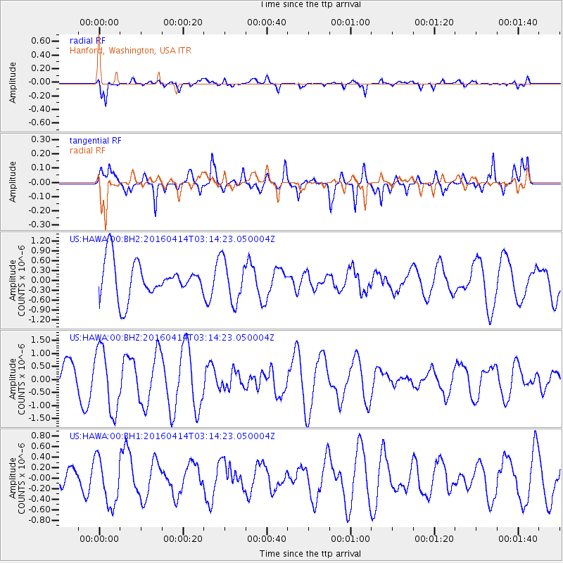
HAWA Hanford, Washington, USA - Earthquake Result Viewer
*The percent match for this event was below the threshold and hence no stack was calculated.
| Earthquake location: |
Near East Coast Of Kamchatka |
| Earthquake latitude/longitude: |
53.9/160.7 |
| Earthquake time(UTC): |
2016/04/14 (105) 03:06:09 GMT |
| Earthquake Depth: |
36 km |
| Earthquake Magnitude: |
5.8 MWW, 5.7 MWB, 5.8 MWC |
| Earthquake Catalog/Contributor: |
NEIC PDE/NEIC COMCAT |
|
| Network: |
US United States National Seismic Network |
| Station: |
HAWA Hanford, Washington, USA |
| Lat/Lon: |
46.39 N/119.53 W |
| Elevation: |
364 m |
|
| Distance: |
49.1 deg |
| Az: |
64.276 deg |
| Baz: |
309.547 deg |
| Ray Param: |
$rayparam |
*The percent match for this event was below the threshold and hence was not used in the summary stack. |
|
| Radial Match: |
79.15646 % |
| Radial Bump: |
400 |
| Transverse Match: |
74.598076 % |
| Transverse Bump: |
382 |
| SOD ConfigId: |
1475611 |
| Insert Time: |
2016-05-19 05:28:29.037 +0000 |
| GWidth: |
2.5 |
| Max Bumps: |
400 |
| Tol: |
0.001 |
|
Signal To Noise
| Channel | StoN | STA | LTA |
| US:HAWA:00:BHZ:20160414T03:14:23.050004Z | 1.5903554 | 1.2216142E-6 | 7.681391E-7 |
| US:HAWA:00:BH1:20160414T03:14:23.050004Z | 1.7943268 | 4.5677655E-7 | 2.5456708E-7 |
| US:HAWA:00:BH2:20160414T03:14:23.050004Z | 1.1760048 | 6.333037E-7 | 5.3852136E-7 |
| Arrivals |
| Ps | |
| PpPs | |
| PsPs/PpSs | |


