You are here: Home > Network List > TA - USArray Transportable Network (new EarthScope stations) Stations List
> Station O19A Miners Draw (BLM), Jensen, UT, USA > Earthquake Result Viewer
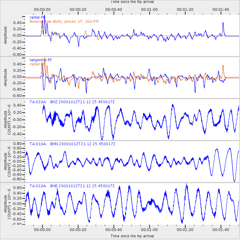
O19A Miners Draw (BLM), Jensen, UT, USA - Earthquake Result Viewer
*The percent match for this event was below the threshold and hence no stack was calculated.
| Earthquake location: |
Vanuatu Islands |
| Earthquake latitude/longitude: |
-14.1/166.3 |
| Earthquake time(UTC): |
2009/10/12 (285) 20:59:38 GMT |
| Earthquake Depth: |
35 km |
| Earthquake Magnitude: |
5.7 MW, 5.4 MS, 5.2 MB, 5.7 MW |
| Earthquake Catalog/Contributor: |
WHDF/NEIC |
|
| Network: |
TA USArray Transportable Network (new EarthScope stations) |
| Station: |
O19A Miners Draw (BLM), Jensen, UT, USA |
| Lat/Lon: |
40.30 N/109.12 W |
| Elevation: |
1649 m |
|
| Distance: |
94.9 deg |
| Az: |
49.845 deg |
| Baz: |
255.859 deg |
| Ray Param: |
$rayparam |
*The percent match for this event was below the threshold and hence was not used in the summary stack. |
|
| Radial Match: |
59.860752 % |
| Radial Bump: |
400 |
| Transverse Match: |
46.792698 % |
| Transverse Bump: |
385 |
| SOD ConfigId: |
2622 |
| Insert Time: |
2010-03-06 10:32:59.110 +0000 |
| GWidth: |
2.5 |
| Max Bumps: |
400 |
| Tol: |
0.001 |
|
Signal To Noise
| Channel | StoN | STA | LTA |
| TA:O19A: :BHN:20091012T21:12:25.450017Z | 0.76075643 | 2.0051594E-7 | 2.6357444E-7 |
| TA:O19A: :BHE:20091012T21:12:25.450017Z | 0.58143026 | 2.8320446E-7 | 4.870824E-7 |
| TA:O19A: :BHZ:20091012T21:12:25.450017Z | 2.1613464 | 3.2899234E-7 | 1.5221639E-7 |
| Arrivals |
| Ps | |
| PpPs | |
| PsPs/PpSs | |


