You are here: Home > Network List > TA - USArray Transportable Network (new EarthScope stations) Stations List
> Station O19A Miners Draw (BLM), Jensen, UT, USA > Earthquake Result Viewer
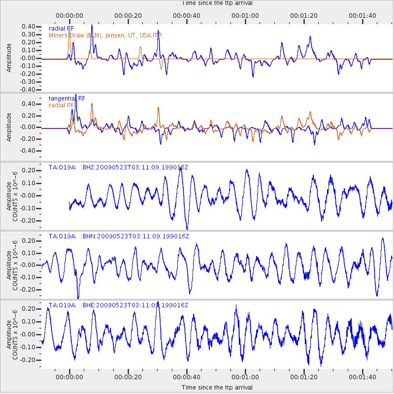
O19A Miners Draw (BLM), Jensen, UT, USA - Earthquake Result Viewer
*The percent match for this event was below the threshold and hence no stack was calculated.
| Earthquake location: |
South Of Fiji Islands |
| Earthquake latitude/longitude: |
-24.4/178.8 |
| Earthquake time(UTC): |
2009/05/23 (143) 02:59:28 GMT |
| Earthquake Depth: |
566 km |
| Earthquake Magnitude: |
5.5 MW, 5.1 MB |
| Earthquake Catalog/Contributor: |
WHDF/NEIC |
|
| Network: |
TA USArray Transportable Network (new EarthScope stations) |
| Station: |
O19A Miners Draw (BLM), Jensen, UT, USA |
| Lat/Lon: |
40.30 N/109.12 W |
| Elevation: |
1649 m |
|
| Distance: |
92.8 deg |
| Az: |
46.753 deg |
| Baz: |
240.277 deg |
| Ray Param: |
$rayparam |
*The percent match for this event was below the threshold and hence was not used in the summary stack. |
|
| Radial Match: |
49.182846 % |
| Radial Bump: |
400 |
| Transverse Match: |
55.83802 % |
| Transverse Bump: |
338 |
| SOD ConfigId: |
2648 |
| Insert Time: |
2010-03-06 10:33:11.426 +0000 |
| GWidth: |
2.5 |
| Max Bumps: |
400 |
| Tol: |
0.001 |
|
Signal To Noise
| Channel | StoN | STA | LTA |
| TA:O19A: :BHN:20090523T03:11:09.199016Z | 1.8395783 | 1.2665355E-7 | 6.8849225E-8 |
| TA:O19A: :BHE:20090523T03:11:09.199016Z | 1.2406613 | 1.077662E-7 | 8.68619E-8 |
| TA:O19A: :BHZ:20090523T03:11:09.199016Z | 1.491199 | 9.1700066E-8 | 6.1494184E-8 |
| Arrivals |
| Ps | |
| PpPs | |
| PsPs/PpSs | |


