You are here: Home > Network List > TA - USArray Transportable Network (new EarthScope stations) Stations List
> Station O19A Miners Draw (BLM), Jensen, UT, USA > Earthquake Result Viewer
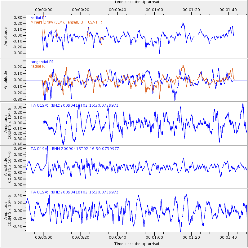
O19A Miners Draw (BLM), Jensen, UT, USA - Earthquake Result Viewer
*The percent match for this event was below the threshold and hence no stack was calculated.
| Earthquake location: |
Kermadec Islands Region |
| Earthquake latitude/longitude: |
-28.9/-177.4 |
| Earthquake time(UTC): |
2009/04/18 (108) 02:03:52 GMT |
| Earthquake Depth: |
65 km |
| Earthquake Magnitude: |
6.0 MB, 5.8 MW, 5.7 MW |
| Earthquake Catalog/Contributor: |
WHDF/NEIC |
|
| Network: |
TA USArray Transportable Network (new EarthScope stations) |
| Station: |
O19A Miners Draw (BLM), Jensen, UT, USA |
| Lat/Lon: |
40.30 N/109.12 W |
| Elevation: |
1649 m |
|
| Distance: |
93.6 deg |
| Az: |
45.407 deg |
| Baz: |
234.714 deg |
| Ray Param: |
$rayparam |
*The percent match for this event was below the threshold and hence was not used in the summary stack. |
|
| Radial Match: |
31.599617 % |
| Radial Bump: |
400 |
| Transverse Match: |
41.479145 % |
| Transverse Bump: |
400 |
| SOD ConfigId: |
2658 |
| Insert Time: |
2010-03-06 10:33:12.178 +0000 |
| GWidth: |
2.5 |
| Max Bumps: |
400 |
| Tol: |
0.001 |
|
Signal To Noise
| Channel | StoN | STA | LTA |
| TA:O19A: :BHN:20090418T02:16:30.073997Z | 2.8363855 | 3.7255867E-7 | 1.3134981E-7 |
| TA:O19A: :BHE:20090418T02:16:30.073997Z | 0.7706581 | 1.9401179E-7 | 2.5174822E-7 |
| TA:O19A: :BHZ:20090418T02:16:30.073997Z | 0.88850725 | 1.555085E-7 | 1.750222E-7 |
| Arrivals |
| Ps | |
| PpPs | |
| PsPs/PpSs | |


