You are here: Home > Network List > PB - Plate Boundary Observatory Borehole Seismic Network Stations List
> Station B087 fordra087bcs2006, Anza, CA, USA > Earthquake Result Viewer
B087 fordra087bcs2006, Anza, CA, USA - Earthquake Result Viewer
| Earthquake location: |
Near Coast Of Central Chile |
| Earthquake latitude/longitude: |
-31.0/-71.6 |
| Earthquake time(UTC): |
2018/04/10 (100) 10:19:34 GMT |
| Earthquake Depth: |
76 km |
| Earthquake Magnitude: |
6.2 Mww |
| Earthquake Catalog/Contributor: |
NEIC PDE/us |
|
| Network: |
PB Plate Boundary Observatory Borehole Seismic Network |
| Station: |
B087 fordra087bcs2006, Anza, CA, USA |
| Lat/Lon: |
33.50 N/116.60 W |
| Elevation: |
1139 m |
|
| Distance: |
77.0 deg |
| Az: |
322.626 deg |
| Baz: |
141.402 deg |
| Ray Param: |
0.050482813 |
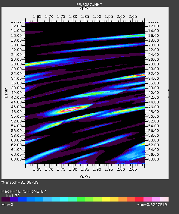
| Estimated Moho Depth: |
46.75 km |
| Estimated Crust Vp/Vs: |
1.79 |
| Assumed Crust Vp: |
6.264 km/s |
| Estimated Crust Vs: |
3.499 km/s |
| Estimated Crust Poisson's Ratio: |
0.27 |
|
| Radial Match: |
81.68733 % |
| Radial Bump: |
400 |
| Transverse Match: |
71.653404 % |
| Transverse Bump: |
400 |
| SOD ConfigId: |
13570011 |
| Insert Time: |
2019-04-30 02:49:10.802 +0000 |
| GWidth: |
2.5 |
| Max Bumps: |
400 |
| Tol: |
0.001 |
|

Signal To Noise
| Channel | StoN | STA | LTA |
| PB:B087: :HHZ:20180410T10:30:47.373994Z | 15.3571005 | 4.5779814E-8 | 2.9810194E-9 |
| PB:B087: :HH1:20180410T10:30:47.373994Z | 1.1166312 | 1.6277975E-8 | 1.4577754E-8 |
| PB:B087: :HH2:20180410T10:30:47.373994Z | 1.318111 | 8.6720195E-9 | 6.579127E-9 |
| Arrivals |
| Ps | 6.1 SECOND |
| PpPs | 20 SECOND |
| PsPs/PpSs | 26 SECOND |


