You are here: Home > Network List > TA - USArray Transportable Network (new EarthScope stations) Stations List
> Station O19A Miners Draw (BLM), Jensen, UT, USA > Earthquake Result Viewer
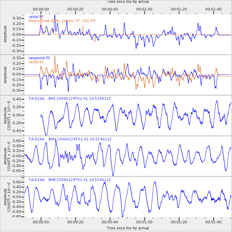
O19A Miners Draw (BLM), Jensen, UT, USA - Earthquake Result Viewer
*The percent match for this event was below the threshold and hence no stack was calculated.
| Earthquake location: |
Kermadec Islands Region |
| Earthquake latitude/longitude: |
-28.2/-176.7 |
| Earthquake time(UTC): |
2009/01/24 (024) 01:28:39 GMT |
| Earthquake Depth: |
10 km |
| Earthquake Magnitude: |
5.5 MB, 5.8 MS, 6.0 MW, 5.8 MW |
| Earthquake Catalog/Contributor: |
WHDF/NEIC |
|
| Network: |
TA USArray Transportable Network (new EarthScope stations) |
| Station: |
O19A Miners Draw (BLM), Jensen, UT, USA |
| Lat/Lon: |
40.30 N/109.12 W |
| Elevation: |
1649 m |
|
| Distance: |
92.6 deg |
| Az: |
45.05 deg |
| Baz: |
234.721 deg |
| Ray Param: |
$rayparam |
*The percent match for this event was below the threshold and hence was not used in the summary stack. |
|
| Radial Match: |
50.552418 % |
| Radial Bump: |
400 |
| Transverse Match: |
37.59695 % |
| Transverse Bump: |
358 |
| SOD ConfigId: |
2658 |
| Insert Time: |
2010-03-06 10:34:06.743 +0000 |
| GWidth: |
2.5 |
| Max Bumps: |
400 |
| Tol: |
0.001 |
|
Signal To Noise
| Channel | StoN | STA | LTA |
| TA:O19A: :BHN:20090124T01:41:19.524011Z | 1.6450741 | 3.2068863E-7 | 1.9493872E-7 |
| TA:O19A: :BHE:20090124T01:41:19.524011Z | 0.18311451 | 5.294064E-8 | 2.891122E-7 |
| TA:O19A: :BHZ:20090124T01:41:19.524011Z | 0.87749064 | 1.7543093E-7 | 1.9992342E-7 |
| Arrivals |
| Ps | |
| PpPs | |
| PsPs/PpSs | |


