You are here: Home > Network List > TA - USArray Transportable Network (new EarthScope stations) Stations List
> Station G23K Bananza Creek, AK, USA > Earthquake Result Viewer
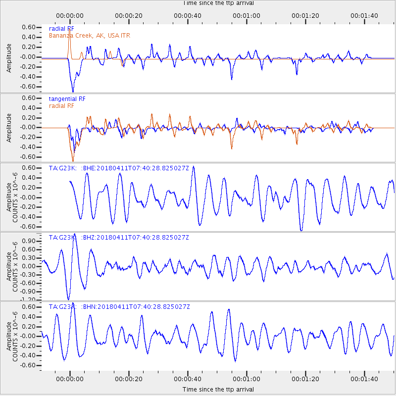
G23K Bananza Creek, AK, USA - Earthquake Result Viewer
*The percent match for this event was below the threshold and hence no stack was calculated.
| Earthquake location: |
Near Coast Of Oaxaca, Mexico |
| Earthquake latitude/longitude: |
15.8/-94.8 |
| Earthquake time(UTC): |
2018/04/11 (101) 07:30:42 GMT |
| Earthquake Depth: |
41 km |
| Earthquake Magnitude: |
5.5 Mww |
| Earthquake Catalog/Contributor: |
NEIC PDE/us |
|
| Network: |
TA USArray Transportable Network (new EarthScope stations) |
| Station: |
G23K Bananza Creek, AK, USA |
| Lat/Lon: |
66.71 N/150.02 W |
| Elevation: |
746 m |
|
| Distance: |
62.2 deg |
| Az: |
338.327 deg |
| Baz: |
116.585 deg |
| Ray Param: |
$rayparam |
*The percent match for this event was below the threshold and hence was not used in the summary stack. |
|
| Radial Match: |
65.22157 % |
| Radial Bump: |
400 |
| Transverse Match: |
74.721504 % |
| Transverse Bump: |
375 |
| SOD ConfigId: |
13570011 |
| Insert Time: |
2019-04-30 02:56:39.242 +0000 |
| GWidth: |
2.5 |
| Max Bumps: |
400 |
| Tol: |
0.001 |
|
Signal To Noise
| Channel | StoN | STA | LTA |
| TA:G23K: :BHZ:20180411T07:40:28.825027Z | 3.0029795 | 7.7119944E-7 | 2.568114E-7 |
| TA:G23K: :BHN:20180411T07:40:28.825027Z | 1.4977759 | 4.0140554E-7 | 2.6800106E-7 |
| TA:G23K: :BHE:20180411T07:40:28.825027Z | 0.43526143 | 1.2270148E-7 | 2.8190294E-7 |
| Arrivals |
| Ps | |
| PpPs | |
| PsPs/PpSs | |


