You are here: Home > Network List > US - United States National Seismic Network Stations List
> Station HAWA Hanford, Washington, USA > Earthquake Result Viewer
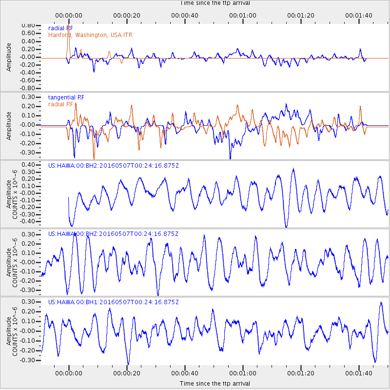
HAWA Hanford, Washington, USA - Earthquake Result Viewer
*The percent match for this event was below the threshold and hence no stack was calculated.
| Earthquake location: |
Off Coast Of Jalisco, Mexico |
| Earthquake latitude/longitude: |
18.4/-105.4 |
| Earthquake time(UTC): |
2016/05/07 (128) 00:18:37 GMT |
| Earthquake Depth: |
13 km |
| Earthquake Magnitude: |
5.7 MO |
| Earthquake Catalog/Contributor: |
NEIC PDE/NEIC ALERT |
|
| Network: |
US United States National Seismic Network |
| Station: |
HAWA Hanford, Washington, USA |
| Lat/Lon: |
46.39 N/119.53 W |
| Elevation: |
364 m |
|
| Distance: |
30.3 deg |
| Az: |
340.374 deg |
| Baz: |
152.564 deg |
| Ray Param: |
$rayparam |
*The percent match for this event was below the threshold and hence was not used in the summary stack. |
|
| Radial Match: |
48.974987 % |
| Radial Bump: |
400 |
| Transverse Match: |
50.746548 % |
| Transverse Bump: |
400 |
| SOD ConfigId: |
1475611 |
| Insert Time: |
2016-05-21 00:22:13.879 +0000 |
| GWidth: |
2.5 |
| Max Bumps: |
400 |
| Tol: |
0.001 |
|
Signal To Noise
| Channel | StoN | STA | LTA |
| US:HAWA:00:BHZ:20160507T00:24:16.875Z | 2.7898223 | 2.4377482E-7 | 8.7380045E-8 |
| US:HAWA:00:BH1:20160507T00:24:16.875Z | 0.7697649 | 9.662283E-8 | 1.2552252E-7 |
| US:HAWA:00:BH2:20160507T00:24:16.875Z | 1.075853 | 1.690896E-7 | 1.5716795E-7 |
| Arrivals |
| Ps | |
| PpPs | |
| PsPs/PpSs | |


