You are here: Home > Network List > TA - USArray Transportable Network (new EarthScope stations) Stations List
> Station 327A Balmorhea Ranch, Pecos, TX, USA > Earthquake Result Viewer
327A Balmorhea Ranch, Pecos, TX, USA - Earthquake Result Viewer
| Earthquake location: |
Off East Coast Of Honshu, Japan |
| Earthquake latitude/longitude: |
37.6/142.2 |
| Earthquake time(UTC): |
2008/07/19 (201) 02:39:28 GMT |
| Earthquake Depth: |
22 km |
| Earthquake Magnitude: |
6.2 MB, 7.0 MS, 7.0 MW, 6.9 MW |
| Earthquake Catalog/Contributor: |
WHDF/NEIC |
|
| Network: |
TA USArray Transportable Network (new EarthScope stations) |
| Station: |
327A Balmorhea Ranch, Pecos, TX, USA |
| Lat/Lon: |
31.37 N/103.49 W |
| Elevation: |
784 m |
|
| Distance: |
88.0 deg |
| Az: |
51.27 deg |
| Baz: |
313.545 deg |
| Ray Param: |
0.04288196 |
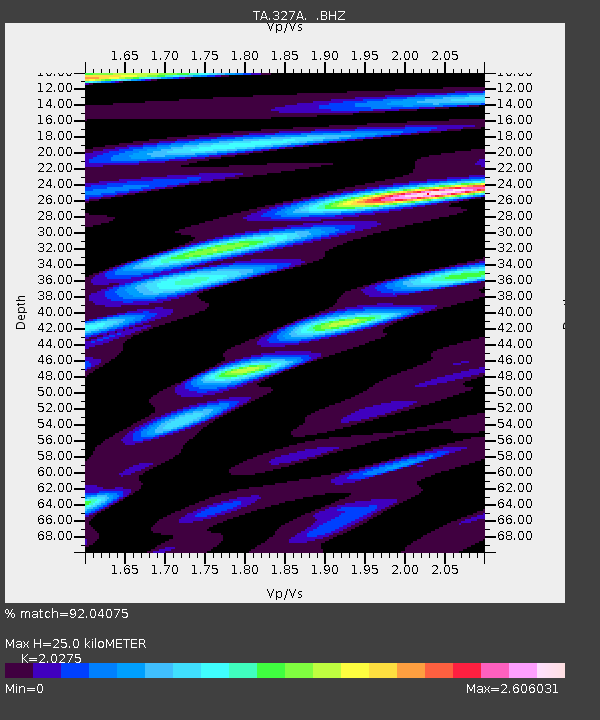
| Estimated Moho Depth: |
25.0 km |
| Estimated Crust Vp/Vs: |
2.03 |
| Assumed Crust Vp: |
6.121 km/s |
| Estimated Crust Vs: |
3.019 km/s |
| Estimated Crust Poisson's Ratio: |
0.34 |
|
| Radial Match: |
92.04075 % |
| Radial Bump: |
400 |
| Transverse Match: |
70.53603 % |
| Transverse Bump: |
400 |
| SOD ConfigId: |
2504 |
| Insert Time: |
2010-03-06 10:35:37.632 +0000 |
| GWidth: |
2.5 |
| Max Bumps: |
400 |
| Tol: |
0.001 |
|
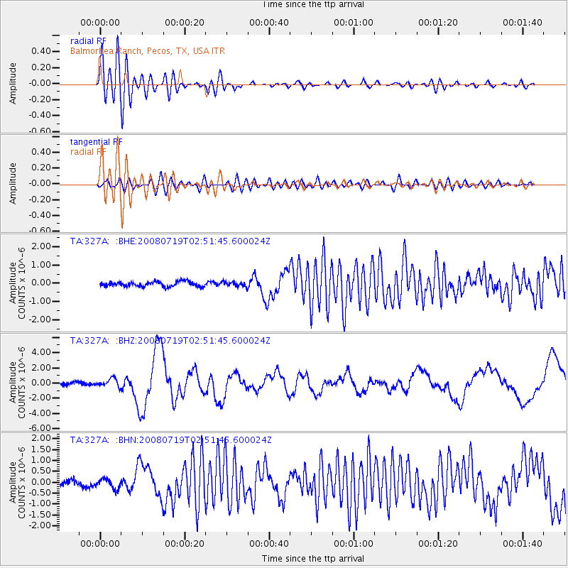
Signal To Noise
| Channel | StoN | STA | LTA |
| TA:327A: :BHZ:20080719T02:51:45.600024Z | 2.7480292 | 5.437632E-7 | 1.9787389E-7 |
| TA:327A: :BHN:20080719T02:51:45.600024Z | 1.716005 | 2.2942574E-7 | 1.3369758E-7 |
| TA:327A: :BHE:20080719T02:51:45.600024Z | 0.94483876 | 1.2469444E-7 | 1.319743E-7 |
| Arrivals |
| Ps | 4.3 SECOND |
| PpPs | 12 SECOND |
| PsPs/PpSs | 16 SECOND |


