You are here: Home > Network List > CN - Canadian National Seismograph Network Stations List
> Station INK INUVIK, NT > Earthquake Result Viewer
INK INUVIK, NT - Earthquake Result Viewer
*The percent match for this event was below the threshold and hence no stack was calculated.
| Earthquake location: |
Northern Molucca Sea |
| Earthquake latitude/longitude: |
1.4/126.9 |
| Earthquake time(UTC): |
2018/04/15 (105) 19:30:43 GMT |
| Earthquake Depth: |
36 km |
| Earthquake Magnitude: |
5.9 Mww |
| Earthquake Catalog/Contributor: |
NEIC PDE/us |
|
| Network: |
CN Canadian National Seismograph Network |
| Station: |
INK INUVIK, NT |
| Lat/Lon: |
68.31 N/133.53 W |
| Elevation: |
44 m |
|
| Distance: |
92.3 deg |
| Az: |
21.523 deg |
| Baz: |
279.427 deg |
| Ray Param: |
$rayparam |
*The percent match for this event was below the threshold and hence was not used in the summary stack. |
|
| Radial Match: |
41.58956 % |
| Radial Bump: |
400 |
| Transverse Match: |
64.54443 % |
| Transverse Bump: |
400 |
| SOD ConfigId: |
13570011 |
| Insert Time: |
2019-04-30 03:02:16.559 +0000 |
| GWidth: |
2.5 |
| Max Bumps: |
400 |
| Tol: |
0.001 |
|
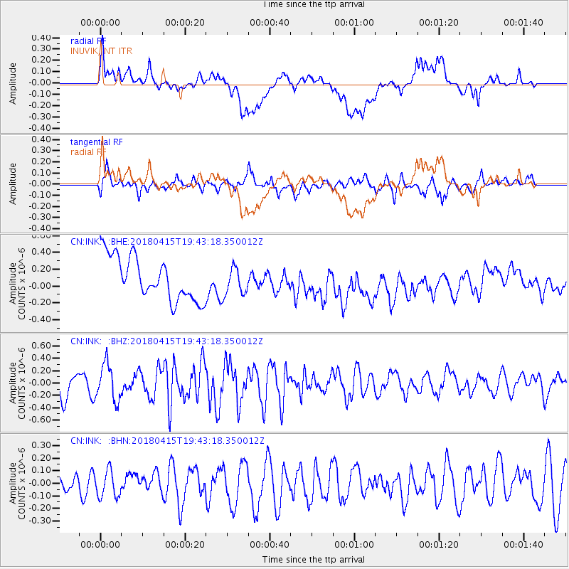
Signal To Noise
| Channel | StoN | STA | LTA |
| CN:INK: :BHZ:20180415T19:43:18.350012Z | 1.8671736 | 2.9636928E-7 | 1.5872615E-7 |
| CN:INK: :BHN:20180415T19:43:18.350012Z | 1.4527483 | 1.0733903E-7 | 7.388687E-8 |
| CN:INK: :BHE:20180415T19:43:18.350012Z | 0.65390617 | 1.6693309E-7 | 2.55286E-7 |
| Arrivals |
| Ps | |
| PpPs | |
| PsPs/PpSs | |


