You are here: Home > Network List > TA - USArray Transportable Network (new EarthScope stations) Stations List
> Station 327A Balmorhea Ranch, Pecos, TX, USA > Earthquake Result Viewer
327A Balmorhea Ranch, Pecos, TX, USA - Earthquake Result Viewer
| Earthquake location: |
Kermadec Islands Region |
| Earthquake latitude/longitude: |
-27.4/-176.3 |
| Earthquake time(UTC): |
2009/02/18 (049) 21:53:45 GMT |
| Earthquake Depth: |
25 km |
| Earthquake Magnitude: |
6.8 MB, 7.2 MS, 6.9 MW, 6.9 MW |
| Earthquake Catalog/Contributor: |
WHDF/NEIC |
|
| Network: |
TA USArray Transportable Network (new EarthScope stations) |
| Station: |
327A Balmorhea Ranch, Pecos, TX, USA |
| Lat/Lon: |
31.37 N/103.49 W |
| Elevation: |
784 m |
|
| Distance: |
90.7 deg |
| Az: |
54.821 deg |
| Baz: |
238.144 deg |
| Ray Param: |
0.041649144 |
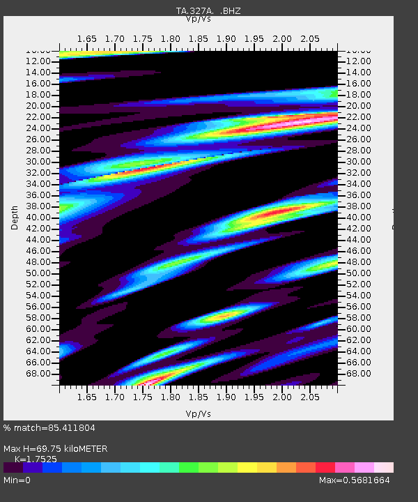
| Estimated Moho Depth: |
69.75 km |
| Estimated Crust Vp/Vs: |
1.75 |
| Assumed Crust Vp: |
6.121 km/s |
| Estimated Crust Vs: |
3.492 km/s |
| Estimated Crust Poisson's Ratio: |
0.26 |
|
| Radial Match: |
85.411804 % |
| Radial Bump: |
400 |
| Transverse Match: |
76.98477 % |
| Transverse Bump: |
400 |
| SOD ConfigId: |
2658 |
| Insert Time: |
2010-03-06 10:35:50.839 +0000 |
| GWidth: |
2.5 |
| Max Bumps: |
400 |
| Tol: |
0.001 |
|
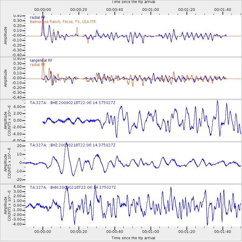
Signal To Noise
| Channel | StoN | STA | LTA |
| TA:327A: :BHZ:20090218T22:06:14.375027Z | 4.702455 | 2.957354E-6 | 6.288957E-7 |
| TA:327A: :BHN:20090218T22:06:14.375027Z | 1.7972589 | 4.825206E-7 | 2.6847584E-7 |
| TA:327A: :BHE:20090218T22:06:14.375027Z | 2.0386074 | 9.2451995E-7 | 4.5350563E-7 |
| Arrivals |
| Ps | 8.7 SECOND |
| PpPs | 31 SECOND |
| PsPs/PpSs | 40 SECOND |


