You are here: Home > Network List > TA - USArray Transportable Network (new EarthScope stations) Stations List
> Station 327A Balmorhea Ranch, Pecos, TX, USA > Earthquake Result Viewer
327A Balmorhea Ranch, Pecos, TX, USA - Earthquake Result Viewer

| Earthquake location: |
Near Coast Of Venezuela |
| Earthquake latitude/longitude: |
10.7/-67.9 |
| Earthquake time(UTC): |
2009/09/12 (255) 20:06:24 GMT |
| Earthquake Depth: |
10 km |
| Earthquake Magnitude: |
6.3 MB, 6.4 MS, 6.3 MW, 6.3 MW |
| Earthquake Catalog/Contributor: |
WHDF/NEIC |
|
| Network: |
TA USArray Transportable Network (new EarthScope stations) |
| Station: |
327A Balmorhea Ranch, Pecos, TX, USA |
| Lat/Lon: |
31.37 N/103.49 W |
| Elevation: |
784 m |
|
| Distance: |
38.8 deg |
| Az: |
307.419 deg |
| Baz: |
114.14 deg |
| Ray Param: |
0.07535591 |
| Estimated Moho Depth: |
10.75 km |
| Estimated Crust Vp/Vs: |
1.60 |
| Assumed Crust Vp: |
6.121 km/s |
| Estimated Crust Vs: |
3.825 km/s |
| Estimated Crust Poisson's Ratio: |
0.18 |
|
| Radial Match: |
82.989746 % |
| Radial Bump: |
400 |
| Transverse Match: |
71.40754 % |
| Transverse Bump: |
400 |
| SOD ConfigId: |
2622 |
| Insert Time: |
2010-03-06 10:35:56.079 +0000 |
| GWidth: |
2.5 |
| Max Bumps: |
400 |
| Tol: |
0.001 |
|
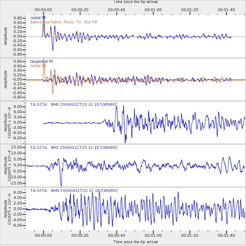
Signal To Noise
| Channel | StoN | STA | LTA |
| TA:327A: :BHZ:20090912T20:13:18.598986Z | 4.9964013 | 1.2834195E-6 | 2.5686876E-7 |
| TA:327A: :BHN:20090912T20:13:18.598986Z | 2.3371785 | 3.4910465E-7 | 1.4937014E-7 |
| TA:327A: :BHE:20090912T20:13:18.598986Z | 4.8250065 | 7.2108753E-7 | 1.49448E-7 |
| Arrivals |
| Ps | 1.1 SECOND |
| PpPs | 4.2 SECOND |
| PsPs/PpSs | 5.4 SECOND |


