You are here: Home > Network List > MM - Myanmar National Seismic Network Stations List
> Station NGU Ngaung U, Myanmar > Earthquake Result Viewer
NGU Ngaung U, Myanmar - Earthquake Result Viewer
| Earthquake location: |
Northern Molucca Sea |
| Earthquake latitude/longitude: |
1.4/126.9 |
| Earthquake time(UTC): |
2018/04/15 (105) 19:30:43 GMT |
| Earthquake Depth: |
36 km |
| Earthquake Magnitude: |
5.9 Mww |
| Earthquake Catalog/Contributor: |
NEIC PDE/us |
|
| Network: |
MM Myanmar National Seismic Network |
| Station: |
NGU Ngaung U, Myanmar |
| Lat/Lon: |
21.21 N/94.92 E |
| Elevation: |
70 m |
|
| Distance: |
36.9 deg |
| Az: |
304.6 deg |
| Baz: |
118.128 deg |
| Ray Param: |
0.07637442 |
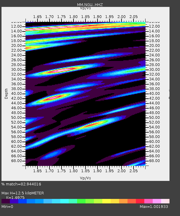
| Estimated Moho Depth: |
12.5 km |
| Estimated Crust Vp/Vs: |
1.70 |
| Assumed Crust Vp: |
6.036 km/s |
| Estimated Crust Vs: |
3.556 km/s |
| Estimated Crust Poisson's Ratio: |
0.23 |
|
| Radial Match: |
82.944016 % |
| Radial Bump: |
400 |
| Transverse Match: |
67.63087 % |
| Transverse Bump: |
400 |
| SOD ConfigId: |
13570011 |
| Insert Time: |
2019-04-30 03:03:15.591 +0000 |
| GWidth: |
2.5 |
| Max Bumps: |
400 |
| Tol: |
0.001 |
|

Signal To Noise
| Channel | StoN | STA | LTA |
| MM:NGU: :HHZ:20180415T19:37:17.829993Z | 7.1187077 | 1.2634019E-6 | 1.7747631E-7 |
| MM:NGU: :HHN:20180415T19:37:17.829993Z | 1.1729051 | 1.8028192E-7 | 1.5370544E-7 |
| MM:NGU: :HHE:20180415T19:37:17.829993Z | 1.5544465 | 3.110983E-7 | 2.0013445E-7 |
| Arrivals |
| Ps | 1.5 SECOND |
| PpPs | 5.2 SECOND |
| PsPs/PpSs | 6.8 SECOND |


