You are here: Home > Network List > TA - USArray Transportable Network (new EarthScope stations) Stations List
> Station E19K Redstone River, AK, USA > Earthquake Result Viewer
E19K Redstone River, AK, USA - Earthquake Result Viewer
| Earthquake location: |
Northern Molucca Sea |
| Earthquake latitude/longitude: |
1.4/126.9 |
| Earthquake time(UTC): |
2018/04/15 (105) 19:30:43 GMT |
| Earthquake Depth: |
36 km |
| Earthquake Magnitude: |
5.9 Mww |
| Earthquake Catalog/Contributor: |
NEIC PDE/us |
|
| Network: |
TA USArray Transportable Network (new EarthScope stations) |
| Station: |
E19K Redstone River, AK, USA |
| Lat/Lon: |
67.46 N/157.23 W |
| Elevation: |
441 m |
|
| Distance: |
83.3 deg |
| Az: |
22.116 deg |
| Baz: |
257.464 deg |
| Ray Param: |
0.04620112 |
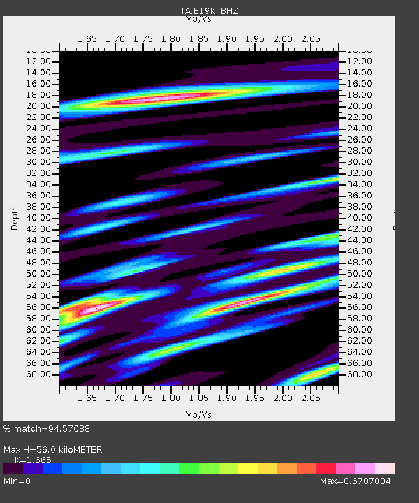
| Estimated Moho Depth: |
56.0 km |
| Estimated Crust Vp/Vs: |
1.66 |
| Assumed Crust Vp: |
6.577 km/s |
| Estimated Crust Vs: |
3.95 km/s |
| Estimated Crust Poisson's Ratio: |
0.22 |
|
| Radial Match: |
94.57088 % |
| Radial Bump: |
400 |
| Transverse Match: |
88.85116 % |
| Transverse Bump: |
400 |
| SOD ConfigId: |
13570011 |
| Insert Time: |
2019-04-30 03:04:00.995 +0000 |
| GWidth: |
2.5 |
| Max Bumps: |
400 |
| Tol: |
0.001 |
|

Signal To Noise
| Channel | StoN | STA | LTA |
| TA:E19K: :BHZ:20180415T19:42:35.400Z | 3.7579913 | 5.5526965E-7 | 1.4775704E-7 |
| TA:E19K: :BHN:20180415T19:42:35.400Z | 0.86865956 | 7.1425355E-8 | 8.2224794E-8 |
| TA:E19K: :BHE:20180415T19:42:35.400Z | 1.59128 | 1.6799548E-7 | 1.05572546E-7 |
| Arrivals |
| Ps | 5.8 SECOND |
| PpPs | 22 SECOND |
| PsPs/PpSs | 28 SECOND |


