You are here: Home > Network List > TA - USArray Transportable Network (new EarthScope stations) Stations List
> Station H31M Peel River, Yukon, CAN > Earthquake Result Viewer
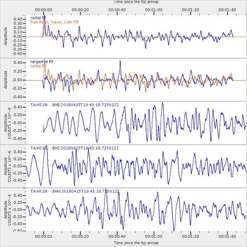
H31M Peel River, Yukon, CAN - Earthquake Result Viewer
*The percent match for this event was below the threshold and hence no stack was calculated.
| Earthquake location: |
Northern Molucca Sea |
| Earthquake latitude/longitude: |
1.4/126.9 |
| Earthquake time(UTC): |
2018/04/15 (105) 19:30:43 GMT |
| Earthquake Depth: |
36 km |
| Earthquake Magnitude: |
5.9 Mww |
| Earthquake Catalog/Contributor: |
NEIC PDE/us |
|
| Network: |
TA USArray Transportable Network (new EarthScope stations) |
| Station: |
H31M Peel River, Yukon, CAN |
| Lat/Lon: |
65.81 N/134.34 W |
| Elevation: |
642 m |
|
| Distance: |
92.4 deg |
| Az: |
24.057 deg |
| Baz: |
278.572 deg |
| Ray Param: |
$rayparam |
*The percent match for this event was below the threshold and hence was not used in the summary stack. |
|
| Radial Match: |
62.02525 % |
| Radial Bump: |
400 |
| Transverse Match: |
59.325703 % |
| Transverse Bump: |
400 |
| SOD ConfigId: |
13570011 |
| Insert Time: |
2019-04-30 03:04:18.447 +0000 |
| GWidth: |
2.5 |
| Max Bumps: |
400 |
| Tol: |
0.001 |
|
Signal To Noise
| Channel | StoN | STA | LTA |
| TA:H31M: :BHZ:20180415T19:43:18.725012Z | 2.4049182 | 3.8798115E-7 | 1.6132822E-7 |
| TA:H31M: :BHN:20180415T19:43:18.725012Z | 0.5345802 | 9.822955E-8 | 1.8375083E-7 |
| TA:H31M: :BHE:20180415T19:43:18.725012Z | 1.3358428 | 2.3468193E-7 | 1.756808E-7 |
| Arrivals |
| Ps | |
| PpPs | |
| PsPs/PpSs | |


