You are here: Home > Network List > TA - USArray Transportable Network (new EarthScope stations) Stations List
> Station C16K Lisburne Hills, AK, USA > Earthquake Result Viewer
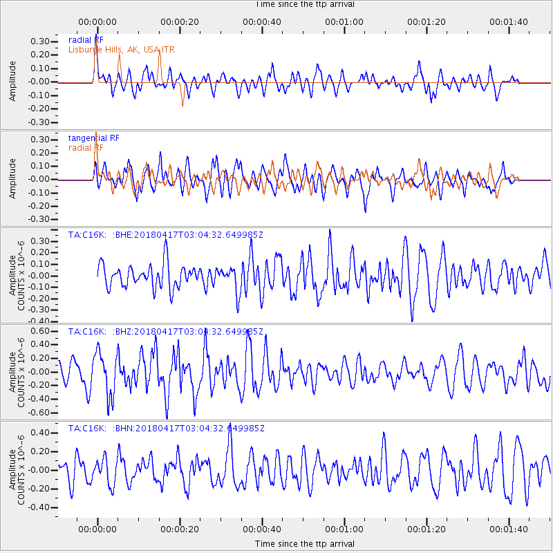
C16K Lisburne Hills, AK, USA - Earthquake Result Viewer
*The percent match for this event was below the threshold and hence no stack was calculated.
| Earthquake location: |
Irian Jaya Region, Indonesia |
| Earthquake latitude/longitude: |
-3.5/131.3 |
| Earthquake time(UTC): |
2018/04/17 (107) 02:52:35 GMT |
| Earthquake Depth: |
10 km |
| Earthquake Magnitude: |
5.5 Mww |
| Earthquake Catalog/Contributor: |
NEIC PDE/us |
|
| Network: |
TA USArray Transportable Network (new EarthScope stations) |
| Station: |
C16K Lisburne Hills, AK, USA |
| Lat/Lon: |
68.27 N/165.34 W |
| Elevation: |
102 m |
|
| Distance: |
83.7 deg |
| Az: |
19.561 deg |
| Baz: |
243.847 deg |
| Ray Param: |
$rayparam |
*The percent match for this event was below the threshold and hence was not used in the summary stack. |
|
| Radial Match: |
63.591305 % |
| Radial Bump: |
400 |
| Transverse Match: |
68.23781 % |
| Transverse Bump: |
400 |
| SOD ConfigId: |
13570011 |
| Insert Time: |
2019-04-30 03:07:11.784 +0000 |
| GWidth: |
2.5 |
| Max Bumps: |
400 |
| Tol: |
0.001 |
|
Signal To Noise
| Channel | StoN | STA | LTA |
| TA:C16K: :BHZ:20180417T03:04:32.649985Z | 2.9471617 | 3.2549892E-7 | 1.1044489E-7 |
| TA:C16K: :BHN:20180417T03:04:32.649985Z | 1.0208144 | 1.3838194E-7 | 1.3556033E-7 |
| TA:C16K: :BHE:20180417T03:04:32.649985Z | 1.1539118 | 1.13627E-7 | 9.847113E-8 |
| Arrivals |
| Ps | |
| PpPs | |
| PsPs/PpSs | |


