You are here: Home > Network List > TA - USArray Transportable Network (new EarthScope stations) Stations List
> Station 327A Balmorhea Ranch, Pecos, TX, USA > Earthquake Result Viewer
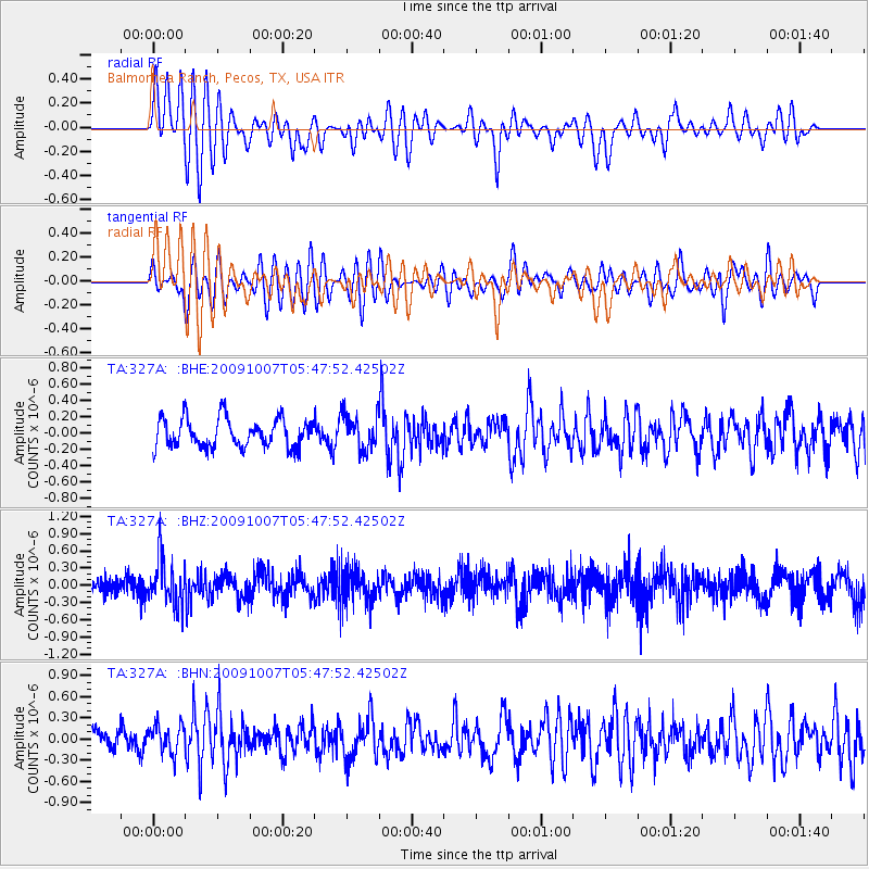
327A Balmorhea Ranch, Pecos, TX, USA - Earthquake Result Viewer
*The percent match for this event was below the threshold and hence no stack was calculated.
| Earthquake location: |
Rat Islands, Aleutian Islands |
| Earthquake latitude/longitude: |
52.2/178.1 |
| Earthquake time(UTC): |
2009/10/07 (280) 05:38:37 GMT |
| Earthquake Depth: |
138 km |
| Earthquake Magnitude: |
5.6 MB, 5.6 MW, 5.6 MW |
| Earthquake Catalog/Contributor: |
WHDF/NEIC |
|
| Network: |
TA USArray Transportable Network (new EarthScope stations) |
| Station: |
327A Balmorhea Ranch, Pecos, TX, USA |
| Lat/Lon: |
31.37 N/103.49 W |
| Elevation: |
784 m |
|
| Distance: |
59.1 deg |
| Az: |
77.599 deg |
| Baz: |
315.298 deg |
| Ray Param: |
$rayparam |
*The percent match for this event was below the threshold and hence was not used in the summary stack. |
|
| Radial Match: |
63.148262 % |
| Radial Bump: |
400 |
| Transverse Match: |
56.318752 % |
| Transverse Bump: |
400 |
| SOD ConfigId: |
2622 |
| Insert Time: |
2010-03-06 10:36:58.782 +0000 |
| GWidth: |
2.5 |
| Max Bumps: |
400 |
| Tol: |
0.001 |
|
Signal To Noise
| Channel | StoN | STA | LTA |
| TA:327A: :BHZ:20091007T05:47:52.42502Z | 2.8006818 | 4.1948712E-7 | 1.4978035E-7 |
| TA:327A: :BHN:20091007T05:47:52.42502Z | 1.1097369 | 1.9997775E-7 | 1.8020285E-7 |
| TA:327A: :BHE:20091007T05:47:52.42502Z | 1.236099 | 2.1700667E-7 | 1.7555767E-7 |
| Arrivals |
| Ps | |
| PpPs | |
| PsPs/PpSs | |


