You are here: Home > Network List > TA - USArray Transportable Network (new EarthScope stations) Stations List
> Station 327A Balmorhea Ranch, Pecos, TX, USA > Earthquake Result Viewer
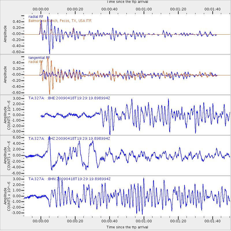
327A Balmorhea Ranch, Pecos, TX, USA - Earthquake Result Viewer
*The percent match for this event was below the threshold and hence no stack was calculated.
| Earthquake location: |
Kuril Islands |
| Earthquake latitude/longitude: |
46.0/151.4 |
| Earthquake time(UTC): |
2009/04/18 (108) 19:17:58 GMT |
| Earthquake Depth: |
35 km |
| Earthquake Magnitude: |
6.3 MB, 6.3 MS, 6.6 MW, 6.4 MW |
| Earthquake Catalog/Contributor: |
WHDF/NEIC |
|
| Network: |
TA USArray Transportable Network (new EarthScope stations) |
| Station: |
327A Balmorhea Ranch, Pecos, TX, USA |
| Lat/Lon: |
31.37 N/103.49 W |
| Elevation: |
784 m |
|
| Distance: |
77.5 deg |
| Az: |
57.776 deg |
| Baz: |
316.432 deg |
| Ray Param: |
$rayparam |
*The percent match for this event was below the threshold and hence was not used in the summary stack. |
|
| Radial Match: |
88.85711 % |
| Radial Bump: |
400 |
| Transverse Match: |
68.16103 % |
| Transverse Bump: |
400 |
| SOD ConfigId: |
2658 |
| Insert Time: |
2010-03-06 10:37:14.688 +0000 |
| GWidth: |
2.5 |
| Max Bumps: |
400 |
| Tol: |
0.001 |
|
Signal To Noise
| Channel | StoN | STA | LTA |
| TA:327A: :BHZ:20090418T19:29:19.898994Z | 7.8446116 | 1.861809E-6 | 2.3733602E-7 |
| TA:327A: :BHN:20090418T19:29:19.898994Z | 1.8121287 | 3.0525158E-7 | 1.6844918E-7 |
| TA:327A: :BHE:20090418T19:29:19.898994Z | 1.5791701 | 3.32722E-7 | 2.1069421E-7 |
| Arrivals |
| Ps | |
| PpPs | |
| PsPs/PpSs | |


