You are here: Home > Network List > TA - USArray Transportable Network (new EarthScope stations) Stations List
> Station 327A Balmorhea Ranch, Pecos, TX, USA > Earthquake Result Viewer
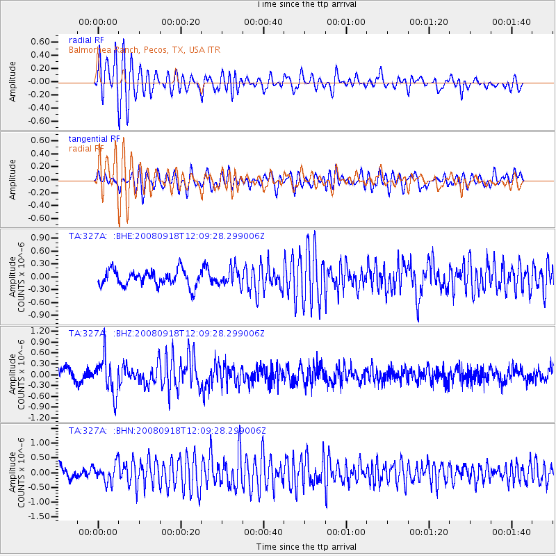
327A Balmorhea Ranch, Pecos, TX, USA - Earthquake Result Viewer
*The percent match for this event was below the threshold and hence no stack was calculated.
| Earthquake location: |
Near East Coast Of Kamchatka |
| Earthquake latitude/longitude: |
51.9/158.4 |
| Earthquake time(UTC): |
2008/09/18 (262) 11:58:50 GMT |
| Earthquake Depth: |
67 km |
| Earthquake Magnitude: |
5.7 MB, 5.9 MW, 5.8 MW |
| Earthquake Catalog/Contributor: |
WHDF/NEIC |
|
| Network: |
TA USArray Transportable Network (new EarthScope stations) |
| Station: |
327A Balmorhea Ranch, Pecos, TX, USA |
| Lat/Lon: |
31.37 N/103.49 W |
| Elevation: |
784 m |
|
| Distance: |
70.6 deg |
| Az: |
63.854 deg |
| Baz: |
319.462 deg |
| Ray Param: |
$rayparam |
*The percent match for this event was below the threshold and hence was not used in the summary stack. |
|
| Radial Match: |
84.04835 % |
| Radial Bump: |
400 |
| Transverse Match: |
69.456535 % |
| Transverse Bump: |
400 |
| SOD ConfigId: |
2560 |
| Insert Time: |
2010-03-06 10:37:52.086 +0000 |
| GWidth: |
2.5 |
| Max Bumps: |
400 |
| Tol: |
0.001 |
|
Signal To Noise
| Channel | StoN | STA | LTA |
| TA:327A: :BHZ:20080918T12:09:28.299006Z | 2.7169542 | 5.280076E-7 | 1.9433806E-7 |
| TA:327A: :BHN:20080918T12:09:28.299006Z | 1.6783864 | 3.1524058E-7 | 1.878236E-7 |
| TA:327A: :BHE:20080918T12:09:28.299006Z | 1.1276152 | 2.052989E-7 | 1.8206468E-7 |
| Arrivals |
| Ps | |
| PpPs | |
| PsPs/PpSs | |


