You are here: Home > Network List > TA - USArray Transportable Network (new EarthScope stations) Stations List
> Station I23K Minto, Yukon-Koyukuk, AK, USA > Earthquake Result Viewer
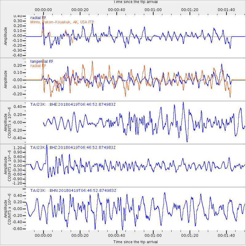
I23K Minto, Yukon-Koyukuk, AK, USA - Earthquake Result Viewer
*The percent match for this event was below the threshold and hence no stack was calculated.
| Earthquake location: |
Southern Iran |
| Earthquake latitude/longitude: |
28.4/51.6 |
| Earthquake time(UTC): |
2018/04/19 (109) 06:34:47 GMT |
| Earthquake Depth: |
10 km |
| Earthquake Magnitude: |
5.5 Mww |
| Earthquake Catalog/Contributor: |
NEIC PDE/us |
|
| Network: |
TA USArray Transportable Network (new EarthScope stations) |
| Station: |
I23K Minto, Yukon-Koyukuk, AK, USA |
| Lat/Lon: |
65.15 N/149.36 W |
| Elevation: |
149 m |
|
| Distance: |
85.4 deg |
| Az: |
8.731 deg |
| Baz: |
341.545 deg |
| Ray Param: |
$rayparam |
*The percent match for this event was below the threshold and hence was not used in the summary stack. |
|
| Radial Match: |
56.09687 % |
| Radial Bump: |
400 |
| Transverse Match: |
50.35587 % |
| Transverse Bump: |
386 |
| SOD ConfigId: |
13570011 |
| Insert Time: |
2019-04-30 03:13:14.715 +0000 |
| GWidth: |
2.5 |
| Max Bumps: |
400 |
| Tol: |
0.001 |
|
Signal To Noise
| Channel | StoN | STA | LTA |
| TA:I23K: :BHZ:20180419T06:46:52.874983Z | 3.422387 | 5.543072E-7 | 1.6196509E-7 |
| TA:I23K: :BHN:20180419T06:46:52.874983Z | 1.349945 | 2.3341312E-7 | 1.7290567E-7 |
| TA:I23K: :BHE:20180419T06:46:52.874983Z | 0.638598 | 7.345277E-8 | 1.1502191E-7 |
| Arrivals |
| Ps | |
| PpPs | |
| PsPs/PpSs | |


