You are here: Home > Network List > US - United States National Seismic Network Stations List
> Station DGMT Dagmar, Montana, USA > Earthquake Result Viewer
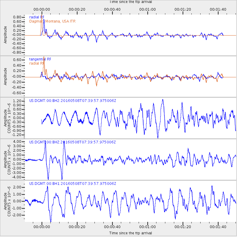
DGMT Dagmar, Montana, USA - Earthquake Result Viewer
*The percent match for this event was below the threshold and hence no stack was calculated.
| Earthquake location: |
Oaxaca, Mexico |
| Earthquake latitude/longitude: |
16.6/-97.7 |
| Earthquake time(UTC): |
2016/05/08 (129) 07:34:02 GMT |
| Earthquake Depth: |
24 km |
| Earthquake Magnitude: |
5.9 MB |
| Earthquake Catalog/Contributor: |
NEIC PDE/NEIC ALERT |
|
| Network: |
US United States National Seismic Network |
| Station: |
DGMT Dagmar, Montana, USA |
| Lat/Lon: |
48.47 N/104.20 W |
| Elevation: |
0.0 m |
|
| Distance: |
32.3 deg |
| Az: |
351.884 deg |
| Baz: |
168.262 deg |
| Ray Param: |
$rayparam |
*The percent match for this event was below the threshold and hence was not used in the summary stack. |
|
| Radial Match: |
87.42803 % |
| Radial Bump: |
344 |
| Transverse Match: |
59.609077 % |
| Transverse Bump: |
400 |
| SOD ConfigId: |
1475611 |
| Insert Time: |
2016-05-22 07:38:52.607 +0000 |
| GWidth: |
2.5 |
| Max Bumps: |
400 |
| Tol: |
0.001 |
|
Signal To Noise
| Channel | StoN | STA | LTA |
| US:DGMT:00:BHZ:20160508T07:39:57.975006Z | 23.15603 | 2.0642328E-6 | 8.91445E-8 |
| US:DGMT:00:BH1:20160508T07:39:57.975006Z | 3.4285817 | 1.1372342E-6 | 3.3169232E-7 |
| US:DGMT:00:BH2:20160508T07:39:57.975006Z | 1.8990088 | 5.54915E-7 | 2.9221297E-7 |
| Arrivals |
| Ps | |
| PpPs | |
| PsPs/PpSs | |


