You are here: Home > Network List > CI - Caltech Regional Seismic Network Stations List
> Station MPM Manuel Prospect Mine, California, USA > Earthquake Result Viewer
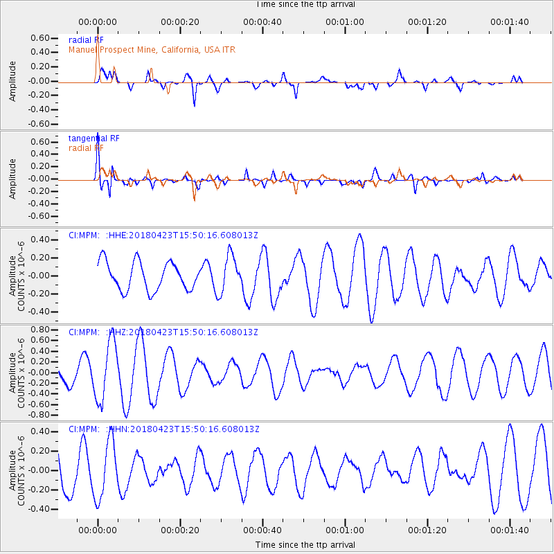
MPM Manuel Prospect Mine, California, USA - Earthquake Result Viewer
*The percent match for this event was below the threshold and hence no stack was calculated.
| Earthquake location: |
Colombia |
| Earthquake latitude/longitude: |
5.2/-75.5 |
| Earthquake time(UTC): |
2018/04/23 (113) 15:42:10 GMT |
| Earthquake Depth: |
113 km |
| Earthquake Magnitude: |
5.2 Mww |
| Earthquake Catalog/Contributor: |
NEIC PDE/us |
|
| Network: |
CI Caltech Regional Seismic Network |
| Station: |
MPM Manuel Prospect Mine, California, USA |
| Lat/Lon: |
36.06 N/117.49 W |
| Elevation: |
185 m |
|
| Distance: |
49.2 deg |
| Az: |
314.355 deg |
| Baz: |
118.494 deg |
| Ray Param: |
$rayparam |
*The percent match for this event was below the threshold and hence was not used in the summary stack. |
|
| Radial Match: |
56.386707 % |
| Radial Bump: |
400 |
| Transverse Match: |
67.968704 % |
| Transverse Bump: |
400 |
| SOD ConfigId: |
13570011 |
| Insert Time: |
2019-04-30 03:32:26.331 +0000 |
| GWidth: |
2.5 |
| Max Bumps: |
400 |
| Tol: |
0.001 |
|
Signal To Noise
| Channel | StoN | STA | LTA |
| CI:MPM: :HHZ:20180423T15:50:16.608013Z | 2.7997322 | 5.63155E-7 | 2.0114604E-7 |
| CI:MPM: :HHN:20180423T15:50:16.608013Z | 1.001327 | 3.002666E-7 | 2.9986867E-7 |
| CI:MPM: :HHE:20180423T15:50:16.608013Z | 1.3515396 | 2.089204E-7 | 1.5457955E-7 |
| Arrivals |
| Ps | |
| PpPs | |
| PsPs/PpSs | |


