You are here: Home > Network List > TA - USArray Transportable Network (new EarthScope stations) Stations List
> Station Z22A Elephant Butte, Truth or Consequences, NM, USA > Earthquake Result Viewer
Z22A Elephant Butte, Truth or Consequences, NM, USA - Earthquake Result Viewer
| Earthquake location: |
Fiji Islands Region |
| Earthquake latitude/longitude: |
-17.3/-177.3 |
| Earthquake time(UTC): |
2008/07/19 (201) 22:39:52 GMT |
| Earthquake Depth: |
391 km |
| Earthquake Magnitude: |
5.9 MB, 6.4 MW, 6.4 MW |
| Earthquake Catalog/Contributor: |
WHDF/NEIC |
|
| Network: |
TA USArray Transportable Network (new EarthScope stations) |
| Station: |
Z22A Elephant Butte, Truth or Consequences, NM, USA |
| Lat/Lon: |
33.26 N/106.96 W |
| Elevation: |
1497 m |
|
| Distance: |
83.8 deg |
| Az: |
52.534 deg |
| Baz: |
244.789 deg |
| Ray Param: |
0.044865828 |
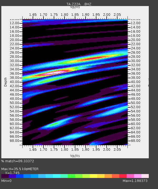
| Estimated Moho Depth: |
35.5 km |
| Estimated Crust Vp/Vs: |
1.75 |
| Assumed Crust Vp: |
6.502 km/s |
| Estimated Crust Vs: |
3.726 km/s |
| Estimated Crust Poisson's Ratio: |
0.26 |
|
| Radial Match: |
89.33372 % |
| Radial Bump: |
400 |
| Transverse Match: |
79.45545 % |
| Transverse Bump: |
400 |
| SOD ConfigId: |
2504 |
| Insert Time: |
2010-03-06 10:41:04.569 +0000 |
| GWidth: |
2.5 |
| Max Bumps: |
400 |
| Tol: |
0.001 |
|
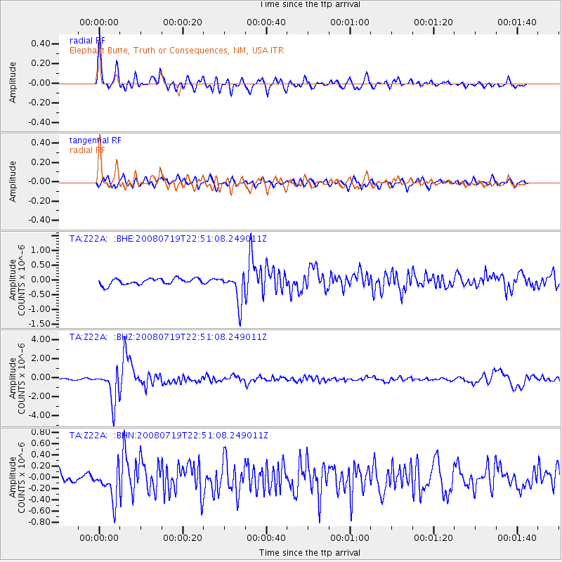
Signal To Noise
| Channel | StoN | STA | LTA |
| TA:Z22A: :BHZ:20080719T22:51:08.249011Z | 22.407589 | 1.738047E-6 | 7.75651E-8 |
| TA:Z22A: :BHN:20080719T22:51:08.249011Z | 2.9961703 | 2.9204614E-7 | 9.7473155E-8 |
| TA:Z22A: :BHE:20080719T22:51:08.249011Z | 5.019855 | 5.19772E-7 | 1.0354323E-7 |
| Arrivals |
| Ps | 4.2 SECOND |
| PpPs | 15 SECOND |
| PsPs/PpSs | 19 SECOND |


