You are here: Home > Network List > TA - USArray Transportable Network (new EarthScope stations) Stations List
> Station Z22A Elephant Butte, Truth or Consequences, NM, USA > Earthquake Result Viewer
Z22A Elephant Butte, Truth or Consequences, NM, USA - Earthquake Result Viewer
| Earthquake location: |
Peru-Brazil Border Region |
| Earthquake latitude/longitude: |
-7.6/-74.4 |
| Earthquake time(UTC): |
2008/08/26 (239) 21:00:36 GMT |
| Earthquake Depth: |
154 km |
| Earthquake Magnitude: |
6.0 MB, 6.4 MW, 6.4 MW |
| Earthquake Catalog/Contributor: |
WHDF/NEIC |
|
| Network: |
TA USArray Transportable Network (new EarthScope stations) |
| Station: |
Z22A Elephant Butte, Truth or Consequences, NM, USA |
| Lat/Lon: |
33.26 N/106.96 W |
| Elevation: |
1497 m |
|
| Distance: |
51.1 deg |
| Az: |
324.568 deg |
| Baz: |
136.701 deg |
| Ray Param: |
0.06708611 |
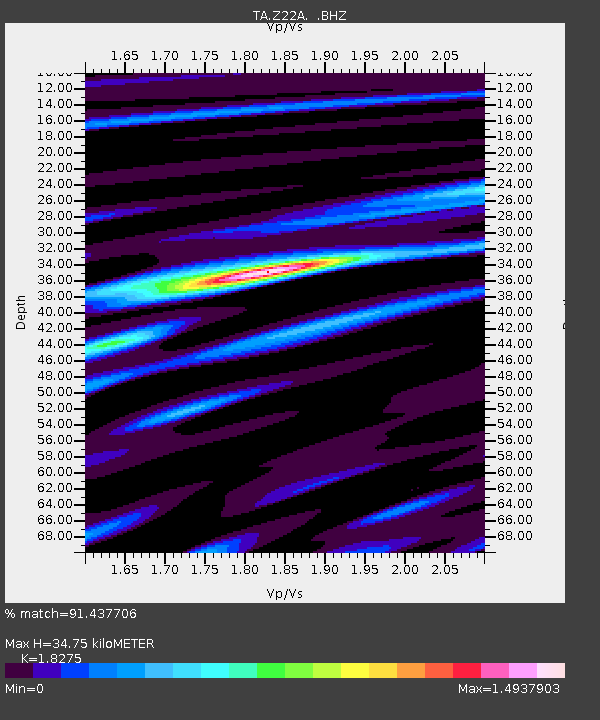
| Estimated Moho Depth: |
34.75 km |
| Estimated Crust Vp/Vs: |
1.83 |
| Assumed Crust Vp: |
6.502 km/s |
| Estimated Crust Vs: |
3.558 km/s |
| Estimated Crust Poisson's Ratio: |
0.29 |
|
| Radial Match: |
91.437706 % |
| Radial Bump: |
400 |
| Transverse Match: |
80.19257 % |
| Transverse Bump: |
400 |
| SOD ConfigId: |
2504 |
| Insert Time: |
2010-03-06 10:41:11.480 +0000 |
| GWidth: |
2.5 |
| Max Bumps: |
400 |
| Tol: |
0.001 |
|
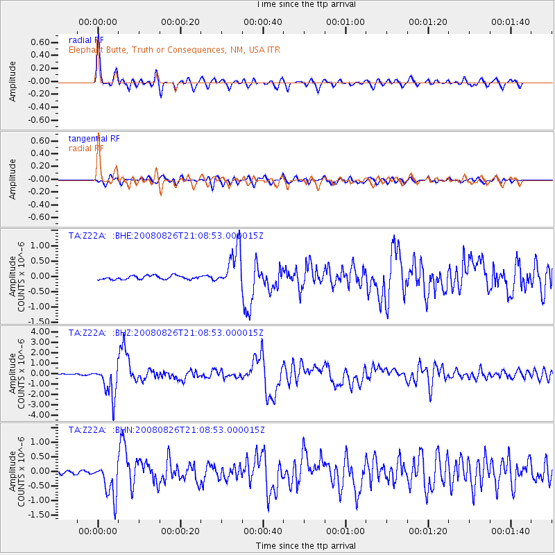
Signal To Noise
| Channel | StoN | STA | LTA |
| TA:Z22A: :BHZ:20080826T21:08:53.000015Z | 19.634722 | 1.5547308E-6 | 7.9182726E-8 |
| TA:Z22A: :BHN:20080826T21:08:53.000015Z | 7.5667953 | 6.2080187E-7 | 8.20429E-8 |
| TA:Z22A: :BHE:20080826T21:08:53.000015Z | 11.069757 | 6.6079286E-7 | 5.969353E-8 |
| Arrivals |
| Ps | 4.7 SECOND |
| PpPs | 14 SECOND |
| PsPs/PpSs | 19 SECOND |


