You are here: Home > Network List > IU - Global Seismograph Network (GSN - IRIS/USGS) Stations List
> Station FURI Mt. Furi, Ethiopia > Earthquake Result Viewer
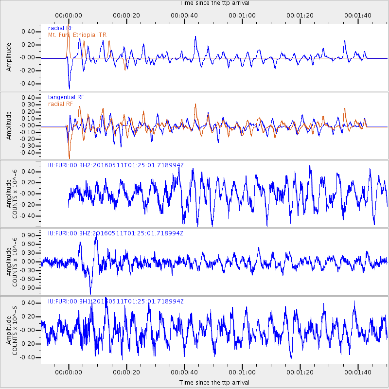
FURI Mt. Furi, Ethiopia - Earthquake Result Viewer
*The percent match for this event was below the threshold and hence no stack was calculated.
| Earthquake location: |
Xizang |
| Earthquake latitude/longitude: |
32.0/95.0 |
| Earthquake time(UTC): |
2016/05/11 (132) 01:15:48 GMT |
| Earthquake Depth: |
10 km |
| Earthquake Magnitude: |
5.5 MB |
| Earthquake Catalog/Contributor: |
NEIC PDE/NEIC ALERT |
|
| Network: |
IU Global Seismograph Network (GSN - IRIS/USGS) |
| Station: |
FURI Mt. Furi, Ethiopia |
| Lat/Lon: |
8.90 N/38.68 E |
| Elevation: |
2570 m |
|
| Distance: |
56.9 deg |
| Az: |
259.06 deg |
| Baz: |
57.552 deg |
| Ray Param: |
$rayparam |
*The percent match for this event was below the threshold and hence was not used in the summary stack. |
|
| Radial Match: |
64.49303 % |
| Radial Bump: |
400 |
| Transverse Match: |
70.4566 % |
| Transverse Bump: |
400 |
| SOD ConfigId: |
1475611 |
| Insert Time: |
2016-05-25 01:18:54.077 +0000 |
| GWidth: |
2.5 |
| Max Bumps: |
400 |
| Tol: |
0.001 |
|
Signal To Noise
| Channel | StoN | STA | LTA |
| IU:FURI:00:BHZ:20160511T01:25:01.718994Z | 2.8340676 | 2.609933E-7 | 9.209142E-8 |
| IU:FURI:00:BH1:20160511T01:25:01.718994Z | 1.065663 | 1.1543076E-7 | 1.0831826E-7 |
| IU:FURI:00:BH2:20160511T01:25:01.718994Z | 1.5219985 | 1.7381771E-7 | 1.1420361E-7 |
| Arrivals |
| Ps | |
| PpPs | |
| PsPs/PpSs | |


