You are here: Home > Network List > TA - USArray Transportable Network (new EarthScope stations) Stations List
> Station A22K Sinclair Lake, AK, USA > Earthquake Result Viewer
A22K Sinclair Lake, AK, USA - Earthquake Result Viewer
| Earthquake location: |
Hokkaido, Japan Region |
| Earthquake latitude/longitude: |
43.4/145.7 |
| Earthquake time(UTC): |
2018/04/24 (114) 08:53:21 GMT |
| Earthquake Depth: |
80 km |
| Earthquake Magnitude: |
5.5 Mww |
| Earthquake Catalog/Contributor: |
NEIC PDE/us |
|
| Network: |
TA USArray Transportable Network (new EarthScope stations) |
| Station: |
A22K Sinclair Lake, AK, USA |
| Lat/Lon: |
71.00 N/154.97 W |
| Elevation: |
6.0 m |
|
| Distance: |
39.8 deg |
| Az: |
26.098 deg |
| Baz: |
258.463 deg |
| Ray Param: |
0.074520424 |
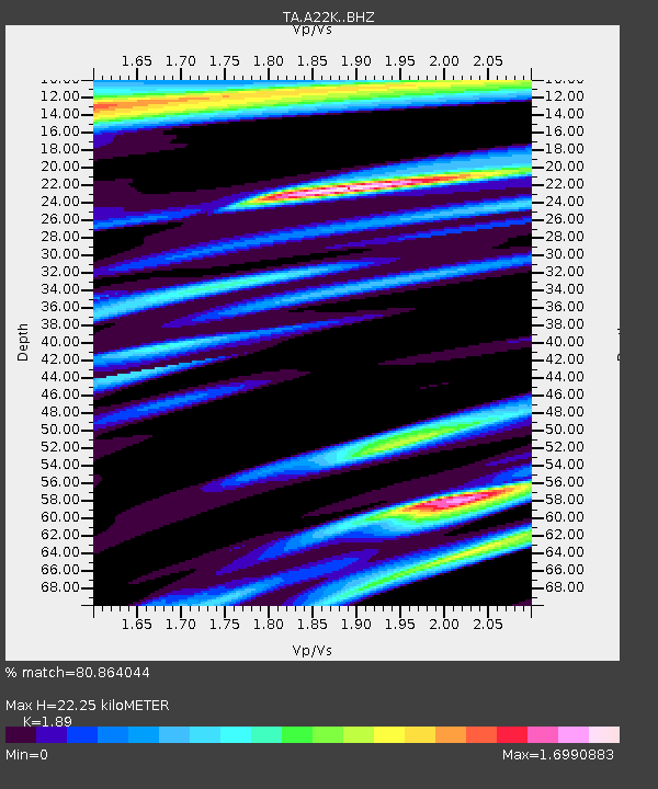
| Estimated Moho Depth: |
22.25 km |
| Estimated Crust Vp/Vs: |
1.89 |
| Assumed Crust Vp: |
5.782 km/s |
| Estimated Crust Vs: |
3.059 km/s |
| Estimated Crust Poisson's Ratio: |
0.31 |
|
| Radial Match: |
80.864044 % |
| Radial Bump: |
398 |
| Transverse Match: |
49.545555 % |
| Transverse Bump: |
400 |
| SOD ConfigId: |
13570011 |
| Insert Time: |
2019-04-30 03:53:50.281 +0000 |
| GWidth: |
2.5 |
| Max Bumps: |
400 |
| Tol: |
0.001 |
|
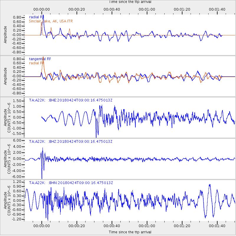
Signal To Noise
| Channel | StoN | STA | LTA |
| TA:A22K: :BHZ:20180424T09:00:16.475013Z | 7.009586 | 1.8146408E-6 | 2.5887988E-7 |
| TA:A22K: :BHN:20180424T09:00:16.475013Z | 1.2132428 | 4.6519915E-7 | 3.8343453E-7 |
| TA:A22K: :BHE:20180424T09:00:16.475013Z | 2.2792392 | 8.135307E-7 | 3.569308E-7 |
| Arrivals |
| Ps | 3.6 SECOND |
| PpPs | 11 SECOND |
| PsPs/PpSs | 14 SECOND |


