You are here: Home > Network List > TA - USArray Transportable Network (new EarthScope stations) Stations List
> Station E20K Nigu River, AK, USA > Earthquake Result Viewer
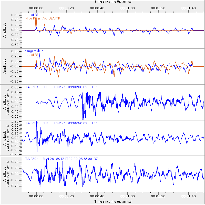
E20K Nigu River, AK, USA - Earthquake Result Viewer
*The percent match for this event was below the threshold and hence no stack was calculated.
| Earthquake location: |
Hokkaido, Japan Region |
| Earthquake latitude/longitude: |
43.4/145.7 |
| Earthquake time(UTC): |
2018/04/24 (114) 08:53:21 GMT |
| Earthquake Depth: |
80 km |
| Earthquake Magnitude: |
5.5 Mww |
| Earthquake Catalog/Contributor: |
NEIC PDE/us |
|
| Network: |
TA USArray Transportable Network (new EarthScope stations) |
| Station: |
E20K Nigu River, AK, USA |
| Lat/Lon: |
68.26 N/156.19 W |
| Elevation: |
866 m |
|
| Distance: |
38.9 deg |
| Az: |
30.257 deg |
| Baz: |
260.543 deg |
| Ray Param: |
$rayparam |
*The percent match for this event was below the threshold and hence was not used in the summary stack. |
|
| Radial Match: |
61.99563 % |
| Radial Bump: |
400 |
| Transverse Match: |
63.700836 % |
| Transverse Bump: |
400 |
| SOD ConfigId: |
13570011 |
| Insert Time: |
2019-04-30 03:54:06.880 +0000 |
| GWidth: |
2.5 |
| Max Bumps: |
400 |
| Tol: |
0.001 |
|
Signal To Noise
| Channel | StoN | STA | LTA |
| TA:E20K: :BHZ:20180424T09:00:08.850013Z | 2.1746542 | 4.649055E-7 | 2.1378364E-7 |
| TA:E20K: :BHN:20180424T09:00:08.850013Z | 1.6072826 | 1.7853445E-7 | 1.1107844E-7 |
| TA:E20K: :BHE:20180424T09:00:08.850013Z | 2.7896004 | 3.4313499E-7 | 1.2300507E-7 |
| Arrivals |
| Ps | |
| PpPs | |
| PsPs/PpSs | |


