You are here: Home > Network List > TA - USArray Transportable Network (new EarthScope stations) Stations List
> Station F20K Avaraart Lake, AK, USA > Earthquake Result Viewer
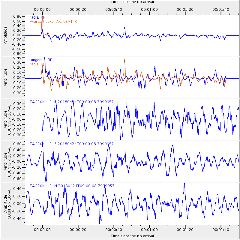
F20K Avaraart Lake, AK, USA - Earthquake Result Viewer
*The percent match for this event was below the threshold and hence no stack was calculated.
| Earthquake location: |
Hokkaido, Japan Region |
| Earthquake latitude/longitude: |
43.4/145.7 |
| Earthquake time(UTC): |
2018/04/24 (114) 08:53:21 GMT |
| Earthquake Depth: |
80 km |
| Earthquake Magnitude: |
5.5 Mww |
| Earthquake Catalog/Contributor: |
NEIC PDE/us |
|
| Network: |
TA USArray Transportable Network (new EarthScope stations) |
| Station: |
F20K Avaraart Lake, AK, USA |
| Lat/Lon: |
67.05 N/155.73 W |
| Elevation: |
136 m |
|
| Distance: |
38.9 deg |
| Az: |
32.214 deg |
| Baz: |
262.494 deg |
| Ray Param: |
$rayparam |
*The percent match for this event was below the threshold and hence was not used in the summary stack. |
|
| Radial Match: |
48.827816 % |
| Radial Bump: |
400 |
| Transverse Match: |
54.40028 % |
| Transverse Bump: |
400 |
| SOD ConfigId: |
13570011 |
| Insert Time: |
2019-04-30 03:54:16.203 +0000 |
| GWidth: |
2.5 |
| Max Bumps: |
400 |
| Tol: |
0.001 |
|
Signal To Noise
| Channel | StoN | STA | LTA |
| TA:F20K: :BHZ:20180424T09:00:08.799995Z | 2.5016906 | 3.5053588E-7 | 1.4011961E-7 |
| TA:F20K: :BHN:20180424T09:00:08.799995Z | 0.88948554 | 1.8662155E-7 | 2.098084E-7 |
| TA:F20K: :BHE:20180424T09:00:08.799995Z | 0.6715058 | 1.2994221E-7 | 1.9350868E-7 |
| Arrivals |
| Ps | |
| PpPs | |
| PsPs/PpSs | |


