You are here: Home > Network List > TA - USArray Transportable Network (new EarthScope stations) Stations List
> Station I17K Unalakleet, AK, USA > Earthquake Result Viewer
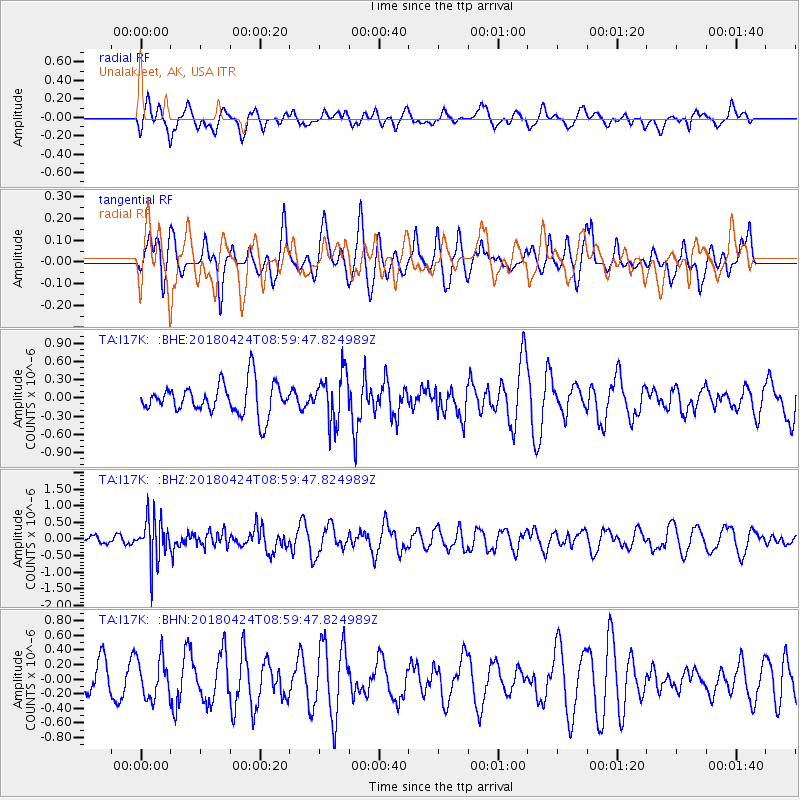
I17K Unalakleet, AK, USA - Earthquake Result Viewer
*The percent match for this event was below the threshold and hence no stack was calculated.
| Earthquake location: |
Hokkaido, Japan Region |
| Earthquake latitude/longitude: |
43.4/145.7 |
| Earthquake time(UTC): |
2018/04/24 (114) 08:53:21 GMT |
| Earthquake Depth: |
80 km |
| Earthquake Magnitude: |
5.5 Mww |
| Earthquake Catalog/Contributor: |
NEIC PDE/us |
|
| Network: |
TA USArray Transportable Network (new EarthScope stations) |
| Station: |
I17K Unalakleet, AK, USA |
| Lat/Lon: |
63.89 N/160.70 W |
| Elevation: |
105 m |
|
| Distance: |
36.4 deg |
| Az: |
36.896 deg |
| Baz: |
261.686 deg |
| Ray Param: |
$rayparam |
*The percent match for this event was below the threshold and hence was not used in the summary stack. |
|
| Radial Match: |
50.036285 % |
| Radial Bump: |
400 |
| Transverse Match: |
50.441177 % |
| Transverse Bump: |
400 |
| SOD ConfigId: |
13570011 |
| Insert Time: |
2019-04-30 03:54:43.821 +0000 |
| GWidth: |
2.5 |
| Max Bumps: |
400 |
| Tol: |
0.001 |
|
Signal To Noise
| Channel | StoN | STA | LTA |
| TA:I17K: :BHZ:20180424T08:59:47.824989Z | 2.913692 | 6.5332506E-7 | 2.2422586E-7 |
| TA:I17K: :BHN:20180424T08:59:47.824989Z | 1.0090355 | 2.7662972E-7 | 2.741526E-7 |
| TA:I17K: :BHE:20180424T08:59:47.824989Z | 1.5259739 | 3.9347648E-7 | 2.578527E-7 |
| Arrivals |
| Ps | |
| PpPs | |
| PsPs/PpSs | |


