You are here: Home > Network List > AK - Alaska Regional Network Stations List
> Station CCB Clear Creek Butte > Earthquake Result Viewer
CCB Clear Creek Butte - Earthquake Result Viewer
| Earthquake location: |
South Of Fiji Islands |
| Earthquake latitude/longitude: |
-23.9/179.8 |
| Earthquake time(UTC): |
2018/04/24 (114) 21:57:00 GMT |
| Earthquake Depth: |
530 km |
| Earthquake Magnitude: |
5.5 Mww |
| Earthquake Catalog/Contributor: |
NEIC PDE/us |
|
| Network: |
AK Alaska Regional Network |
| Station: |
CCB Clear Creek Butte |
| Lat/Lon: |
64.65 N/147.80 W |
| Elevation: |
248 m |
|
| Distance: |
91.8 deg |
| Az: |
13.332 deg |
| Baz: |
209.347 deg |
| Ray Param: |
0.04120203 |
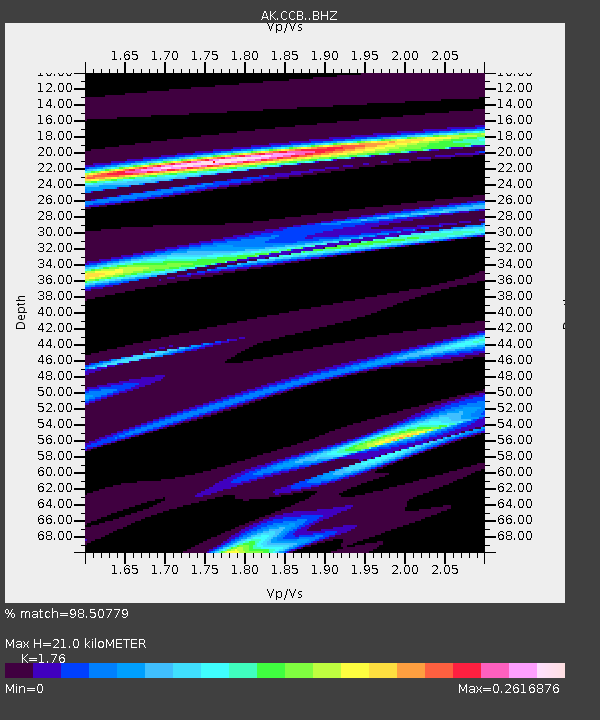
| Estimated Moho Depth: |
21.0 km |
| Estimated Crust Vp/Vs: |
1.76 |
| Assumed Crust Vp: |
6.566 km/s |
| Estimated Crust Vs: |
3.731 km/s |
| Estimated Crust Poisson's Ratio: |
0.26 |
|
| Radial Match: |
98.50779 % |
| Radial Bump: |
117 |
| Transverse Match: |
98.8976 % |
| Transverse Bump: |
112 |
| SOD ConfigId: |
13570011 |
| Insert Time: |
2019-04-30 03:57:06.875 +0000 |
| GWidth: |
2.5 |
| Max Bumps: |
400 |
| Tol: |
0.001 |
|

Signal To Noise
| Channel | StoN | STA | LTA |
| AK:CCB: :BHZ:20180424T22:08:40.16802Z | 0.7843759 | 2.3656999E-6 | 3.0160281E-6 |
| AK:CCB: :BHN:20180424T22:08:40.16802Z | 0.80578464 | 2.955869E-6 | 3.6683114E-6 |
| AK:CCB: :BHE:20180424T22:08:40.16802Z | 0.80131894 | 1.7058172E-6 | 2.128762E-6 |
| Arrivals |
| Ps | 2.5 SECOND |
| PpPs | 8.6 SECOND |
| PsPs/PpSs | 11 SECOND |


