You are here: Home > Network List > TA - USArray Transportable Network (new EarthScope stations) Stations List
> Station D25K Kavik River, AK, USA > Earthquake Result Viewer
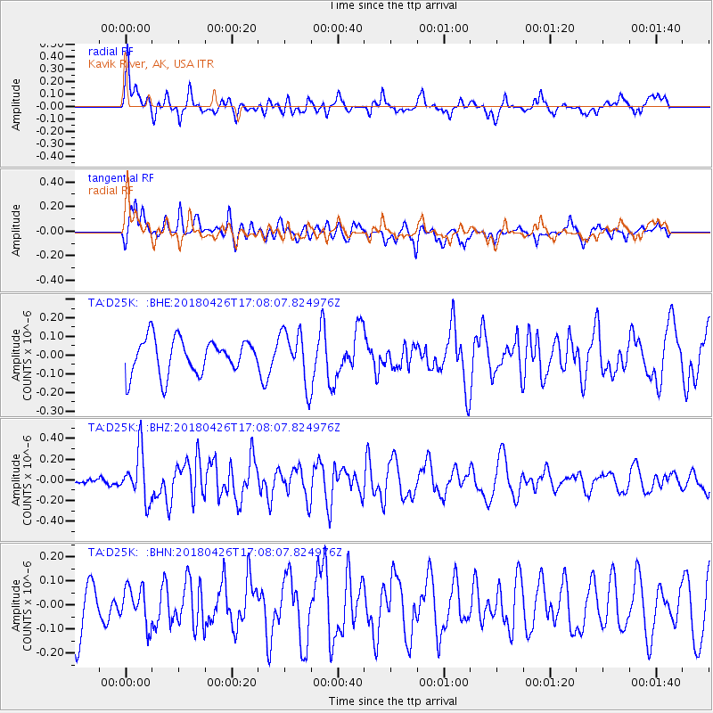
D25K Kavik River, AK, USA - Earthquake Result Viewer
*The percent match for this event was below the threshold and hence no stack was calculated.
| Earthquake location: |
Near North Coast Of Irian Jaya |
| Earthquake latitude/longitude: |
-1.9/139.8 |
| Earthquake time(UTC): |
2018/04/26 (116) 16:55:58 GMT |
| Earthquake Depth: |
10 km |
| Earthquake Magnitude: |
5.6 Mww |
| Earthquake Catalog/Contributor: |
NEIC PDE/us |
|
| Network: |
TA USArray Transportable Network (new EarthScope stations) |
| Station: |
D25K Kavik River, AK, USA |
| Lat/Lon: |
69.32 N/146.38 W |
| Elevation: |
770 m |
|
| Distance: |
86.1 deg |
| Az: |
19.996 deg |
| Baz: |
254.2 deg |
| Ray Param: |
$rayparam |
*The percent match for this event was below the threshold and hence was not used in the summary stack. |
|
| Radial Match: |
49.622612 % |
| Radial Bump: |
400 |
| Transverse Match: |
57.71793 % |
| Transverse Bump: |
400 |
| SOD ConfigId: |
13570011 |
| Insert Time: |
2019-04-30 04:05:09.048 +0000 |
| GWidth: |
2.5 |
| Max Bumps: |
400 |
| Tol: |
0.001 |
|
Signal To Noise
| Channel | StoN | STA | LTA |
| TA:D25K: :BHZ:20180426T17:08:07.824976Z | 3.2824538 | 2.3470515E-7 | 7.150296E-8 |
| TA:D25K: :BHN:20180426T17:08:07.824976Z | 0.60454804 | 7.728599E-8 | 1.2784093E-7 |
| TA:D25K: :BHE:20180426T17:08:07.824976Z | 1.530035 | 1.4294199E-7 | 9.342399E-8 |
| Arrivals |
| Ps | |
| PpPs | |
| PsPs/PpSs | |


