You are here: Home > Network List > TA - USArray Transportable Network (new EarthScope stations) Stations List
> Station F21K Alatna River, AK, USA > Earthquake Result Viewer
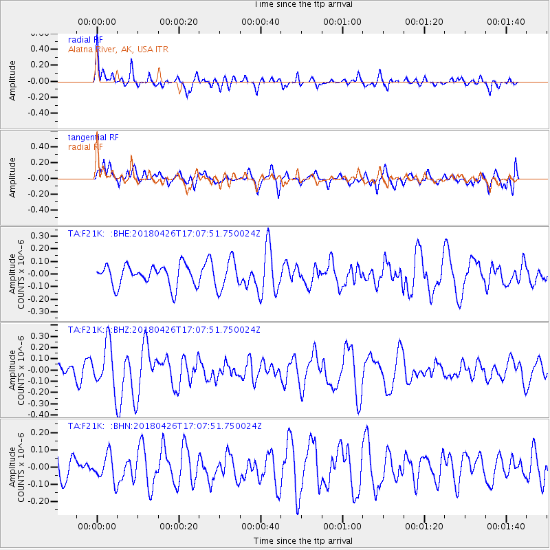
F21K Alatna River, AK, USA - Earthquake Result Viewer
*The percent match for this event was below the threshold and hence no stack was calculated.
| Earthquake location: |
Near North Coast Of Irian Jaya |
| Earthquake latitude/longitude: |
-1.9/139.8 |
| Earthquake time(UTC): |
2018/04/26 (116) 16:55:58 GMT |
| Earthquake Depth: |
10 km |
| Earthquake Magnitude: |
5.6 Mww |
| Earthquake Catalog/Contributor: |
NEIC PDE/us |
|
| Network: |
TA USArray Transportable Network (new EarthScope stations) |
| Station: |
F21K Alatna River, AK, USA |
| Lat/Lon: |
67.22 N/153.48 W |
| Elevation: |
597 m |
|
| Distance: |
82.9 deg |
| Az: |
21.129 deg |
| Baz: |
247.709 deg |
| Ray Param: |
$rayparam |
*The percent match for this event was below the threshold and hence was not used in the summary stack. |
|
| Radial Match: |
57.43787 % |
| Radial Bump: |
400 |
| Transverse Match: |
60.75644 % |
| Transverse Bump: |
400 |
| SOD ConfigId: |
13570011 |
| Insert Time: |
2019-04-30 04:05:21.150 +0000 |
| GWidth: |
2.5 |
| Max Bumps: |
400 |
| Tol: |
0.001 |
|
Signal To Noise
| Channel | StoN | STA | LTA |
| TA:F21K: :BHZ:20180426T17:07:51.750024Z | 3.7359717 | 2.0874108E-7 | 5.5873308E-8 |
| TA:F21K: :BHN:20180426T17:07:51.750024Z | 0.9839367 | 7.87077E-8 | 7.9992645E-8 |
| TA:F21K: :BHE:20180426T17:07:51.750024Z | 1.4827152 | 1.2095296E-7 | 8.157531E-8 |
| Arrivals |
| Ps | |
| PpPs | |
| PsPs/PpSs | |


