You are here: Home > Network List > UW - Pacific Northwest Regional Seismic Network Stations List
> Station FISH Seaside, OR, USA > Earthquake Result Viewer
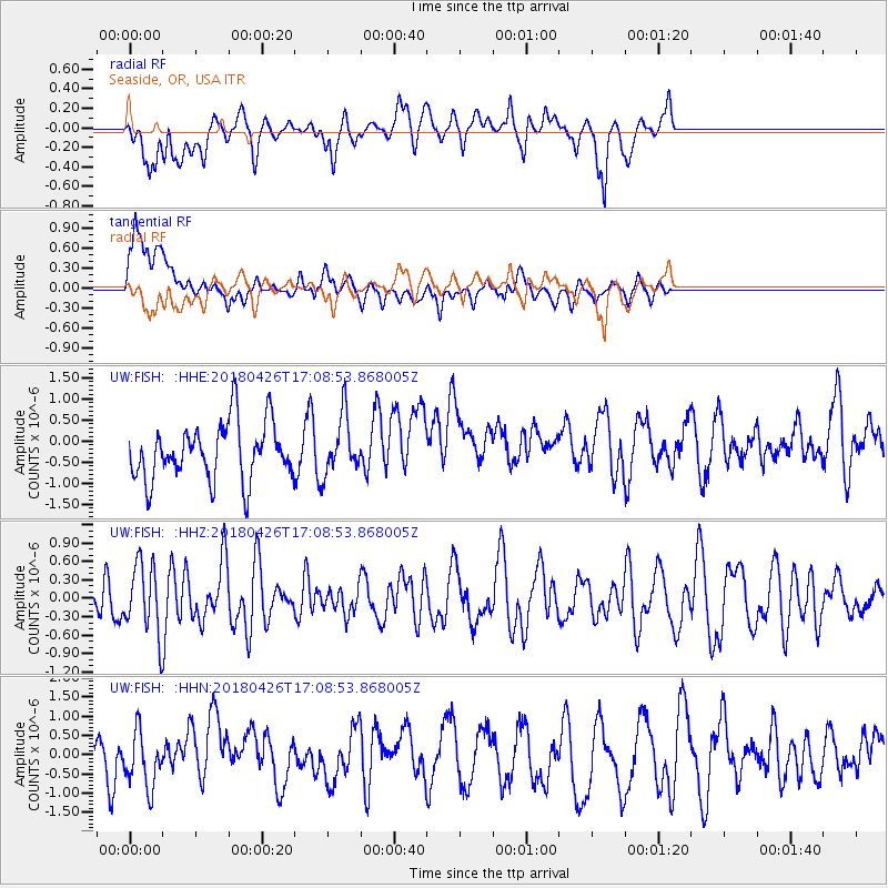
FISH Seaside, OR, USA - Earthquake Result Viewer
*The percent match for this event was below the threshold and hence no stack was calculated.
| Earthquake location: |
Near North Coast Of Irian Jaya |
| Earthquake latitude/longitude: |
-1.9/139.8 |
| Earthquake time(UTC): |
2018/04/26 (116) 16:55:58 GMT |
| Earthquake Depth: |
10 km |
| Earthquake Magnitude: |
5.6 Mww |
| Earthquake Catalog/Contributor: |
NEIC PDE/us |
|
| Network: |
UW Pacific Northwest Regional Seismic Network |
| Station: |
FISH Seaside, OR, USA |
| Lat/Lon: |
45.93 N/123.56 W |
| Elevation: |
325 m |
|
| Distance: |
96.0 deg |
| Az: |
44.19 deg |
| Baz: |
273.459 deg |
| Ray Param: |
$rayparam |
*The percent match for this event was below the threshold and hence was not used in the summary stack. |
|
| Radial Match: |
52.183437 % |
| Radial Bump: |
400 |
| Transverse Match: |
46.70185 % |
| Transverse Bump: |
400 |
| SOD ConfigId: |
13570011 |
| Insert Time: |
2019-04-30 04:06:25.241 +0000 |
| GWidth: |
2.5 |
| Max Bumps: |
400 |
| Tol: |
0.001 |
|
Signal To Noise
| Channel | StoN | STA | LTA |
| UW:FISH: :HHZ:20180426T17:08:53.868005Z | 1.6462477 | 5.461487E-7 | 3.3175365E-7 |
| UW:FISH: :HHN:20180426T17:08:53.868005Z | 1.1218039 | 6.8869764E-7 | 6.1391984E-7 |
| UW:FISH: :HHE:20180426T17:08:53.868005Z | 1.0289205 | 6.8800676E-7 | 6.686685E-7 |
| Arrivals |
| Ps | |
| PpPs | |
| PsPs/PpSs | |


