You are here: Home > Network List > US - United States National Seismic Network Stations List
> Station MSO Missoula, Montana, USA > Earthquake Result Viewer
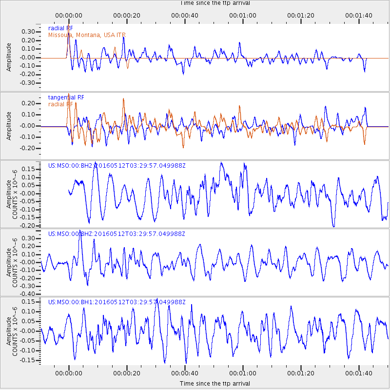
MSO Missoula, Montana, USA - Earthquake Result Viewer
*The percent match for this event was below the threshold and hence no stack was calculated.
| Earthquake location: |
Taiwan |
| Earthquake latitude/longitude: |
24.7/122.0 |
| Earthquake time(UTC): |
2016/05/12 (133) 03:17:16 GMT |
| Earthquake Depth: |
10 km |
| Earthquake Magnitude: |
5.6 MB |
| Earthquake Catalog/Contributor: |
NEIC PDE/NEIC COMCAT |
|
| Network: |
US United States National Seismic Network |
| Station: |
MSO Missoula, Montana, USA |
| Lat/Lon: |
46.83 N/113.94 W |
| Elevation: |
1264 m |
|
| Distance: |
92.8 deg |
| Az: |
34.699 deg |
| Baz: |
311.038 deg |
| Ray Param: |
$rayparam |
*The percent match for this event was below the threshold and hence was not used in the summary stack. |
|
| Radial Match: |
58.816395 % |
| Radial Bump: |
400 |
| Transverse Match: |
57.870808 % |
| Transverse Bump: |
400 |
| SOD ConfigId: |
1475611 |
| Insert Time: |
2016-05-26 03:21:50.019 +0000 |
| GWidth: |
2.5 |
| Max Bumps: |
400 |
| Tol: |
0.001 |
|
Signal To Noise
| Channel | StoN | STA | LTA |
| US:MSO:00:BHZ:20160512T03:29:57.049988Z | 2.0525694 | 1.7244314E-7 | 8.401331E-8 |
| US:MSO:00:BH1:20160512T03:29:57.049988Z | 1.596341 | 6.96395E-8 | 4.3624446E-8 |
| US:MSO:00:BH2:20160512T03:29:57.049988Z | 1.0372924 | 9.214484E-8 | 8.883209E-8 |
| Arrivals |
| Ps | |
| PpPs | |
| PsPs/PpSs | |


