You are here: Home > Network List > TA - USArray Transportable Network (new EarthScope stations) Stations List
> Station X25A Clemmons Ranch, Yeso, NM, USA > Earthquake Result Viewer
X25A Clemmons Ranch, Yeso, NM, USA - Earthquake Result Viewer
| Earthquake location: |
Peru-Brazil Border Region |
| Earthquake latitude/longitude: |
-7.6/-74.4 |
| Earthquake time(UTC): |
2008/08/26 (239) 21:00:36 GMT |
| Earthquake Depth: |
154 km |
| Earthquake Magnitude: |
6.0 MB, 6.4 MW, 6.4 MW |
| Earthquake Catalog/Contributor: |
WHDF/NEIC |
|
| Network: |
TA USArray Transportable Network (new EarthScope stations) |
| Station: |
X25A Clemmons Ranch, Yeso, NM, USA |
| Lat/Lon: |
34.53 N/104.66 W |
| Elevation: |
1494 m |
|
| Distance: |
50.8 deg |
| Az: |
327.495 deg |
| Baz: |
139.822 deg |
| Ray Param: |
0.06730206 |
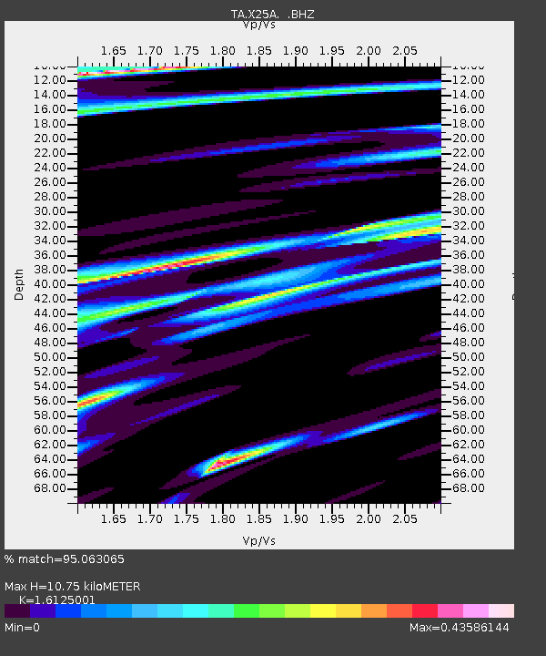
| Estimated Moho Depth: |
10.75 km |
| Estimated Crust Vp/Vs: |
1.61 |
| Assumed Crust Vp: |
6.419 km/s |
| Estimated Crust Vs: |
3.981 km/s |
| Estimated Crust Poisson's Ratio: |
0.19 |
|
| Radial Match: |
95.063065 % |
| Radial Bump: |
393 |
| Transverse Match: |
79.77793 % |
| Transverse Bump: |
400 |
| SOD ConfigId: |
2504 |
| Insert Time: |
2010-03-06 10:45:06.770 +0000 |
| GWidth: |
2.5 |
| Max Bumps: |
400 |
| Tol: |
0.001 |
|
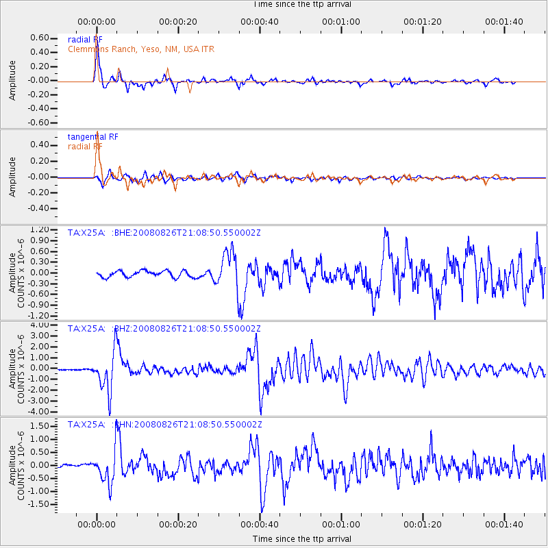
Signal To Noise
| Channel | StoN | STA | LTA |
| TA:X25A: :BHZ:20080826T21:08:50.550002Z | 34.568768 | 1.9331956E-6 | 5.592318E-8 |
| TA:X25A: :BHN:20080826T21:08:50.550002Z | 9.793223 | 6.538666E-7 | 6.676725E-8 |
| TA:X25A: :BHE:20080826T21:08:50.550002Z | 6.000384 | 5.3470615E-7 | 8.911199E-8 |
| Arrivals |
| Ps | 1.1 SECOND |
| PpPs | 4.1 SECOND |
| PsPs/PpSs | 5.2 SECOND |


