You are here: Home > Network List > CI - Caltech Regional Seismic Network Stations List
> Station MPM Manuel Prospect Mine, California, USA > Earthquake Result Viewer
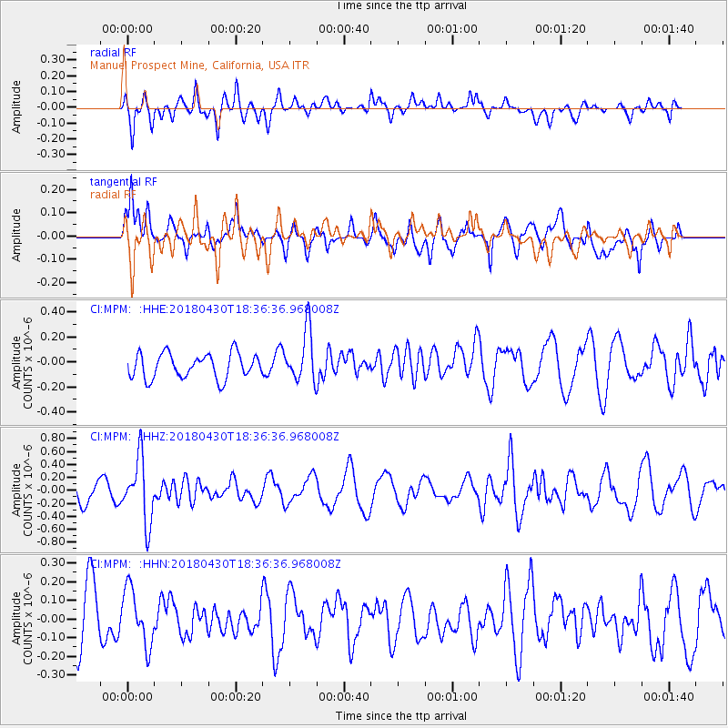
MPM Manuel Prospect Mine, California, USA - Earthquake Result Viewer
*The percent match for this event was below the threshold and hence no stack was calculated.
| Earthquake location: |
Vanuatu Islands |
| Earthquake latitude/longitude: |
-16.0/168.3 |
| Earthquake time(UTC): |
2018/04/30 (120) 18:24:54 GMT |
| Earthquake Depth: |
269 km |
| Earthquake Magnitude: |
5.8 Mww |
| Earthquake Catalog/Contributor: |
NEIC PDE/us |
|
| Network: |
CI Caltech Regional Seismic Network |
| Station: |
MPM Manuel Prospect Mine, California, USA |
| Lat/Lon: |
36.06 N/117.49 W |
| Elevation: |
185 m |
|
| Distance: |
87.0 deg |
| Az: |
51.323 deg |
| Baz: |
247.942 deg |
| Ray Param: |
$rayparam |
*The percent match for this event was below the threshold and hence was not used in the summary stack. |
|
| Radial Match: |
51.42408 % |
| Radial Bump: |
400 |
| Transverse Match: |
62.74188 % |
| Transverse Bump: |
400 |
| SOD ConfigId: |
13570011 |
| Insert Time: |
2019-04-30 04:11:50.727 +0000 |
| GWidth: |
2.5 |
| Max Bumps: |
400 |
| Tol: |
0.001 |
|
Signal To Noise
| Channel | StoN | STA | LTA |
| CI:MPM: :HHZ:20180430T18:36:36.968008Z | 3.7552433 | 4.950653E-7 | 1.3183308E-7 |
| CI:MPM: :HHN:20180430T18:36:36.968008Z | 0.99319017 | 1.5594821E-7 | 1.5701748E-7 |
| CI:MPM: :HHE:20180430T18:36:36.968008Z | 2.1890194 | 2.1618541E-7 | 9.875901E-8 |
| Arrivals |
| Ps | |
| PpPs | |
| PsPs/PpSs | |


