You are here: Home > Network List > TA - USArray Transportable Network (new EarthScope stations) Stations List
> Station X25A Clemmons Ranch, Yeso, NM, USA > Earthquake Result Viewer
X25A Clemmons Ranch, Yeso, NM, USA - Earthquake Result Viewer
| Earthquake location: |
Near Coast Of Venezuela |
| Earthquake latitude/longitude: |
10.7/-67.9 |
| Earthquake time(UTC): |
2009/09/12 (255) 20:06:24 GMT |
| Earthquake Depth: |
10 km |
| Earthquake Magnitude: |
6.3 MB, 6.4 MS, 6.3 MW, 6.3 MW |
| Earthquake Catalog/Contributor: |
WHDF/NEIC |
|
| Network: |
TA USArray Transportable Network (new EarthScope stations) |
| Station: |
X25A Clemmons Ranch, Yeso, NM, USA |
| Lat/Lon: |
34.53 N/104.66 W |
| Elevation: |
1494 m |
|
| Distance: |
41.0 deg |
| Az: |
311.203 deg |
| Baz: |
116.41 deg |
| Ray Param: |
0.07404691 |
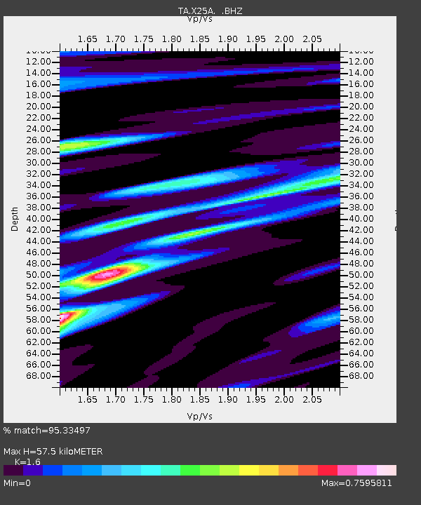
| Estimated Moho Depth: |
57.5 km |
| Estimated Crust Vp/Vs: |
1.60 |
| Assumed Crust Vp: |
6.419 km/s |
| Estimated Crust Vs: |
4.012 km/s |
| Estimated Crust Poisson's Ratio: |
0.18 |
|
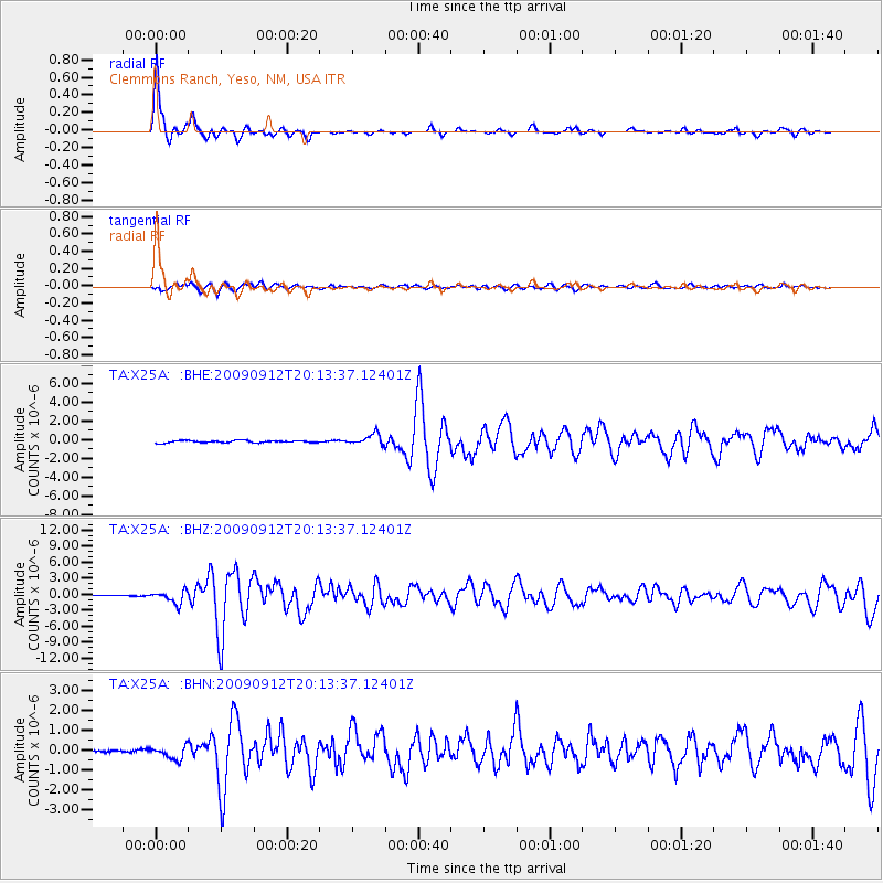
| Radial Match: |
95.33497 % |
| Radial Bump: |
292 |
| Transverse Match: |
80.79332 % |
| Transverse Bump: |
400 |
| SOD ConfigId: |
2622 |
| Insert Time: |
2010-03-06 10:45:44.334 +0000 |
| GWidth: |
2.5 |
| Max Bumps: |
400 |
| Tol: |
0.001 |
|
Signal To Noise
| Channel | StoN | STA | LTA |
| TA:X25A: :BHZ:20090912T20:13:37.12401Z | 11.6097555 | 1.1656026E-6 | 1.0039856E-7 |
| TA:X25A: :BHN:20090912T20:13:37.12401Z | 3.7872708 | 3.4090408E-7 | 9.0013124E-8 |
| TA:X25A: :BHE:20090912T20:13:37.12401Z | 5.01635 | 5.907126E-7 | 1.1775746E-7 |
| Arrivals |
| Ps | 5.8 SECOND |
| PpPs | 22 SECOND |
| PsPs/PpSs | 27 SECOND |


