You are here: Home > Network List > TA - USArray Transportable Network (new EarthScope stations) Stations List
> Station X25A Clemmons Ranch, Yeso, NM, USA > Earthquake Result Viewer
X25A Clemmons Ranch, Yeso, NM, USA - Earthquake Result Viewer
| Earthquake location: |
Samoa Islands Region |
| Earthquake latitude/longitude: |
-15.5/-172.1 |
| Earthquake time(UTC): |
2009/09/29 (272) 17:48:10 GMT |
| Earthquake Depth: |
18 km |
| Earthquake Magnitude: |
7.1 MB, 8.1 MS, 8.1 MW, 8.0 MW |
| Earthquake Catalog/Contributor: |
WHDF/NEIC |
|
| Network: |
TA USArray Transportable Network (new EarthScope stations) |
| Station: |
X25A Clemmons Ranch, Yeso, NM, USA |
| Lat/Lon: |
34.53 N/104.66 W |
| Elevation: |
1494 m |
|
| Distance: |
81.0 deg |
| Az: |
50.519 deg |
| Baz: |
244.332 deg |
| Ray Param: |
0.047851797 |
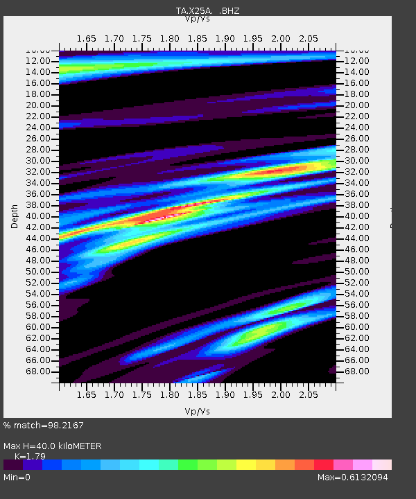
| Estimated Moho Depth: |
40.0 km |
| Estimated Crust Vp/Vs: |
1.79 |
| Assumed Crust Vp: |
6.419 km/s |
| Estimated Crust Vs: |
3.586 km/s |
| Estimated Crust Poisson's Ratio: |
0.27 |
|
| Radial Match: |
98.2167 % |
| Radial Bump: |
327 |
| Transverse Match: |
94.897446 % |
| Transverse Bump: |
400 |
| SOD ConfigId: |
2622 |
| Insert Time: |
2010-03-06 10:45:48.584 +0000 |
| GWidth: |
2.5 |
| Max Bumps: |
400 |
| Tol: |
0.001 |
|

Signal To Noise
| Channel | StoN | STA | LTA |
| TA:X25A: :BHZ:20090929T17:59:53.325022Z | 21.936869 | 3.0875626E-6 | 1.4074764E-7 |
| TA:X25A: :BHN:20090929T17:59:53.325022Z | 4.2007217 | 4.9135383E-7 | 1.16968906E-7 |
| TA:X25A: :BHE:20090929T17:59:53.325022Z | 6.065976 | 7.842841E-7 | 1.2929232E-7 |
| Arrivals |
| Ps | 5.1 SECOND |
| PpPs | 17 SECOND |
| PsPs/PpSs | 22 SECOND |


