You are here: Home > Network List > AZ - ANZA Regional Network Stations List
> Station SMER AZ.SMER > Earthquake Result Viewer
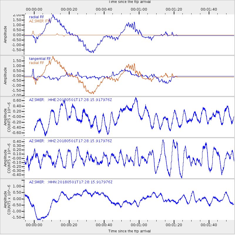
SMER AZ.SMER - Earthquake Result Viewer
*The percent match for this event was below the threshold and hence no stack was calculated.
| Earthquake location: |
Pacific-Antarctic Ridge |
| Earthquake latitude/longitude: |
-56.7/-142.0 |
| Earthquake time(UTC): |
2018/05/01 (121) 17:15:37 GMT |
| Earthquake Depth: |
10 km |
| Earthquake Magnitude: |
5.8 Mww |
| Earthquake Catalog/Contributor: |
NEIC PDE/us |
|
| Network: |
AZ ANZA Regional Network |
| Station: |
SMER AZ.SMER |
| Lat/Lon: |
33.46 N/117.17 W |
| Elevation: |
355 m |
|
| Distance: |
92.3 deg |
| Az: |
20.572 deg |
| Baz: |
193.395 deg |
| Ray Param: |
$rayparam |
*The percent match for this event was below the threshold and hence was not used in the summary stack. |
|
| Radial Match: |
65.342445 % |
| Radial Bump: |
400 |
| Transverse Match: |
56.635807 % |
| Transverse Bump: |
400 |
| SOD ConfigId: |
13570011 |
| Insert Time: |
2019-04-30 04:16:40.715 +0000 |
| GWidth: |
2.5 |
| Max Bumps: |
400 |
| Tol: |
0.001 |
|
Signal To Noise
| Channel | StoN | STA | LTA |
| AZ:SMER: :HHZ:20180501T17:28:15.917976Z | 0.94130456 | 1.2304632E-7 | 1.3071892E-7 |
| AZ:SMER: :HHN:20180501T17:28:15.917976Z | 4.822057 | 1.7184304E-6 | 3.5636876E-7 |
| AZ:SMER: :HHE:20180501T17:28:15.917976Z | 0.62144935 | 2.0035527E-7 | 3.224E-7 |
| Arrivals |
| Ps | |
| PpPs | |
| PsPs/PpSs | |


