You are here: Home > Network List > TA - USArray Transportable Network (new EarthScope stations) Stations List
> Station X25A Clemmons Ranch, Yeso, NM, USA > Earthquake Result Viewer
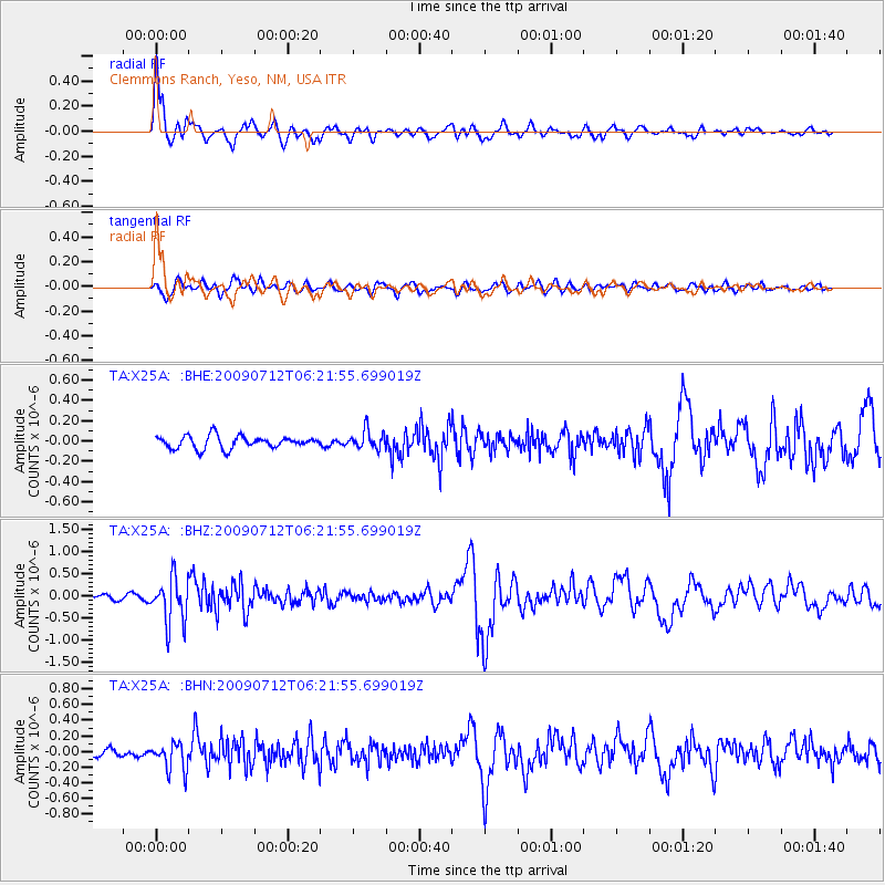
X25A Clemmons Ranch, Yeso, NM, USA - Earthquake Result Viewer
| Earthquake location: |
Southern Peru |
| Earthquake latitude/longitude: |
-15.0/-70.4 |
| Earthquake time(UTC): |
2009/07/12 (193) 06:12:47 GMT |
| Earthquake Depth: |
199 km |
| Earthquake Magnitude: |
5.7 MB, 6.1 MW, 6.1 MW |
| Earthquake Catalog/Contributor: |
WHDF/NEIC |
|
| Network: |
TA USArray Transportable Network (new EarthScope stations) |
| Station: |
X25A Clemmons Ranch, Yeso, NM, USA |
| Lat/Lon: |
34.53 N/104.66 W |
| Elevation: |
1494 m |
|
| Distance: |
59.1 deg |
| Az: |
327.228 deg |
| Baz: |
140.696 deg |
| Ray Param: |
0.061790276 |
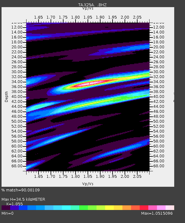
| Estimated Moho Depth: |
34.5 km |
| Estimated Crust Vp/Vs: |
1.86 |
| Assumed Crust Vp: |
6.419 km/s |
| Estimated Crust Vs: |
3.461 km/s |
| Estimated Crust Poisson's Ratio: |
0.30 |
|
| Radial Match: |
90.08109 % |
| Radial Bump: |
400 |
| Transverse Match: |
74.31262 % |
| Transverse Bump: |
400 |
| SOD ConfigId: |
2648 |
| Insert Time: |
2010-03-06 10:46:22.831 +0000 |
| GWidth: |
2.5 |
| Max Bumps: |
400 |
| Tol: |
0.001 |
|
Signal To Noise
| Channel | StoN | STA | LTA |
| TA:X25A: :BHZ:20090712T06:21:55.699019Z | 10.660331 | 5.1189915E-7 | 4.8019068E-8 |
| TA:X25A: :BHN:20090712T06:21:55.699019Z | 3.9556239 | 1.7457222E-7 | 4.4132662E-8 |
| TA:X25A: :BHE:20090712T06:21:55.699019Z | 1.4689078 | 8.9636686E-8 | 6.1022675E-8 |
| Arrivals |
| Ps | 4.8 SECOND |
| PpPs | 15 SECOND |
| PsPs/PpSs | 19 SECOND |


