You are here: Home > Network List > TA - USArray Transportable Network (new EarthScope stations) Stations List
> Station X25A Clemmons Ranch, Yeso, NM, USA > Earthquake Result Viewer
X25A Clemmons Ranch, Yeso, NM, USA - Earthquake Result Viewer
| Earthquake location: |
Kuril Islands |
| Earthquake latitude/longitude: |
46.0/151.5 |
| Earthquake time(UTC): |
2009/04/07 (097) 04:23:33 GMT |
| Earthquake Depth: |
31 km |
| Earthquake Magnitude: |
6.5 MB, 6.8 MS, 6.9 MW, 6.9 MW |
| Earthquake Catalog/Contributor: |
WHDF/NEIC |
|
| Network: |
TA USArray Transportable Network (new EarthScope stations) |
| Station: |
X25A Clemmons Ranch, Yeso, NM, USA |
| Lat/Lon: |
34.53 N/104.66 W |
| Elevation: |
1494 m |
|
| Distance: |
74.5 deg |
| Az: |
56.329 deg |
| Baz: |
315.41 deg |
| Ray Param: |
0.052271385 |
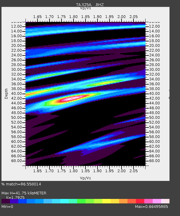
| Estimated Moho Depth: |
41.75 km |
| Estimated Crust Vp/Vs: |
1.79 |
| Assumed Crust Vp: |
6.419 km/s |
| Estimated Crust Vs: |
3.581 km/s |
| Estimated Crust Poisson's Ratio: |
0.27 |
|
| Radial Match: |
96.558014 % |
| Radial Bump: |
370 |
| Transverse Match: |
86.75551 % |
| Transverse Bump: |
400 |
| SOD ConfigId: |
2658 |
| Insert Time: |
2010-03-06 10:46:28.237 +0000 |
| GWidth: |
2.5 |
| Max Bumps: |
400 |
| Tol: |
0.001 |
|
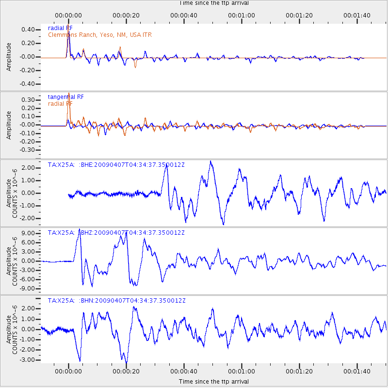
Signal To Noise
| Channel | StoN | STA | LTA |
| TA:X25A: :BHZ:20090407T04:34:37.350012Z | 27.75653 | 4.6630944E-6 | 1.679999E-7 |
| TA:X25A: :BHN:20090407T04:34:37.350012Z | 6.7746754 | 1.3117244E-6 | 1.9362174E-7 |
| TA:X25A: :BHE:20090407T04:34:37.350012Z | 9.808907 | 1.0300984E-6 | 1.0501663E-7 |
| Arrivals |
| Ps | 5.3 SECOND |
| PpPs | 18 SECOND |
| PsPs/PpSs | 23 SECOND |


